
Google Maps will be your greatest ally
There are those who boast of having a keen sense of direction, but even the members of that species capable of finding that address they visited that remote day -using visual memory as a tool, of course - have had to resort more than once to our beloved maps.
What would our lives be without a roadmap? Either on foot or behind the wheel , since sixteen years many of us we consult Google Maps assiduously.

What would our lives be without a roadmap?
And it is that no matter how much we have lost the romantic act of grab a paper map from the glove box , we have benefited from other advantages, see: get up-to-date traffic information during our route or to know if our favorite restaurant It's open.
since it was invented Google Maps in 2005 , technological advances have caused this useful application to advance at a dizzying pace. So much so that this year it will include over 100 improvements powered by artificial intelligence , offering more accurate information to users.
Indoor Live View
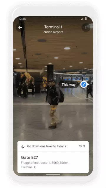
To avoid mistakes during our course, the company will implement Indoor LiveView, that allows greater orientation through augmented reality signs.
This new function incorporates the call global localization , a technology that uses artificial intelligence to scan tens of billions of street view images and know where the user in question is going.
At the same time, thanks to the new advances that allow knowing with precision the altitude and the position of the objects inside a building, live view you can enter public spaces such as airports, transport hubs and shopping centers.
In this way, find the elevator or the escalator closer, the boarding gate or the platform , the baggage reclaim carousel, check-in counters , the lockers, the bathrooms, the ATMs or the store we want to go to, It will no longer be a challenge against the clock.
Indoor Live View is now available for Android and iOS at Chicago, Long Island, Los Angeles, Newark, San Francisco, San Jose, and Seattle , and in the coming months it will also be in Tokyo and Zurich.
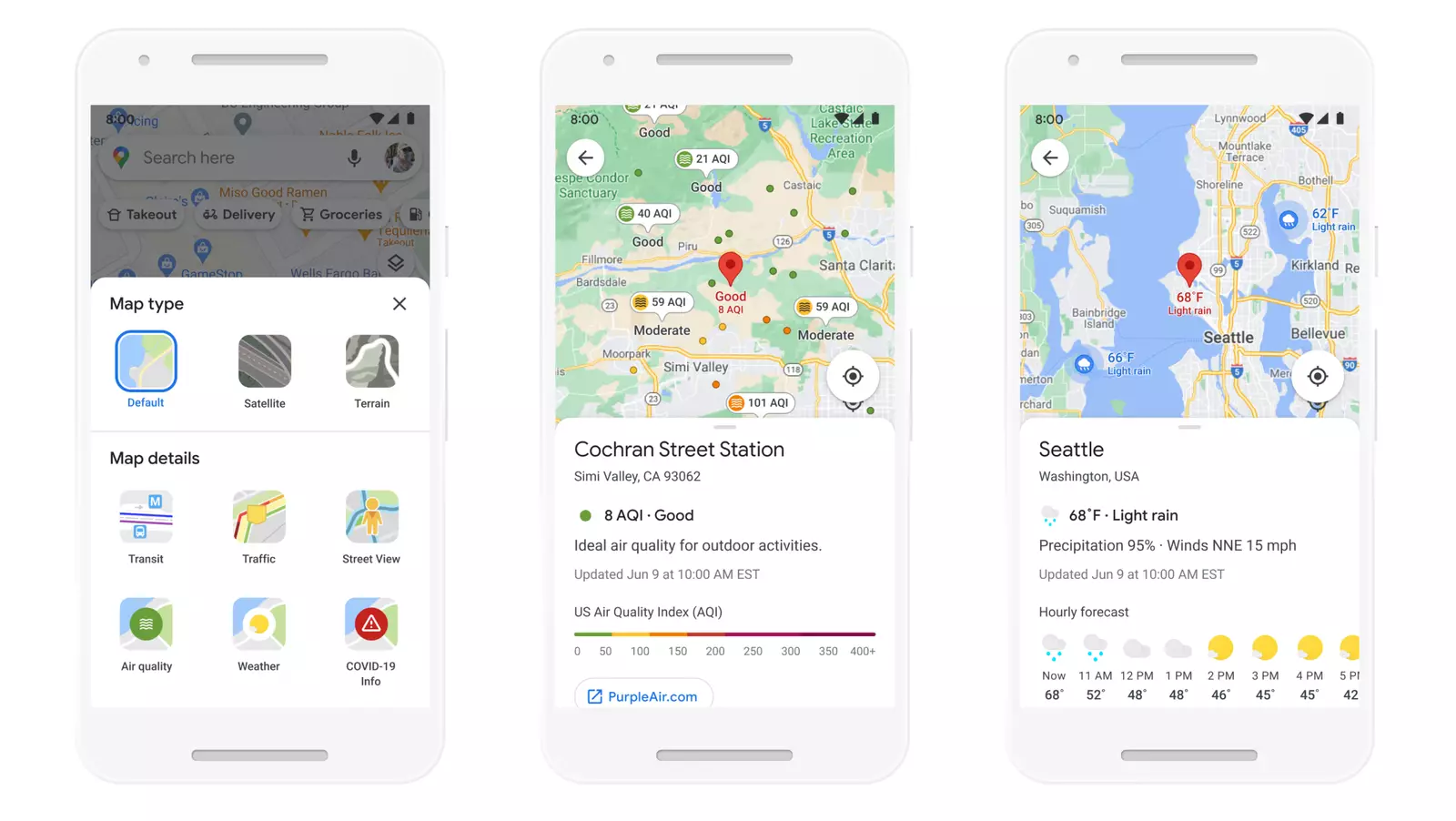
The meteorological layer will allow to know the quality of the air
On the other hand, the new weather layer will allow you to quickly know current temperature and weather conditions and planned for a certain area. In addition to incorporating a function that assesses air quality : from pollen count to contamination.
The Weather Company, AirNow.gov and the Central Pollution Board It is the companies that provide this useful data.
The weather layer will soon be available worldwide and the air quality will be launched first in Australia, India and the US. , to which, as will happen with Indoor Live View, other countries will be added.
Another example of how artificial intelligence has transformed Google is the new model of route tracing based on a lower fuel consumption. For its elaboration, they have been based on the studies of the National Renewable Energy Lab.
Take into account factors such as slopes and traffic congestion of roads will be decisive in achieving reduce carbon footprint.
Soon, Google Maps will suggest the route with the lowest carbon footprint by default, as long as the estimated time of arrival is similar to the fastest route. If it is longer than the most polluting, the user will be able to compare the emissions and choose the itinerary that best suits your preferences.
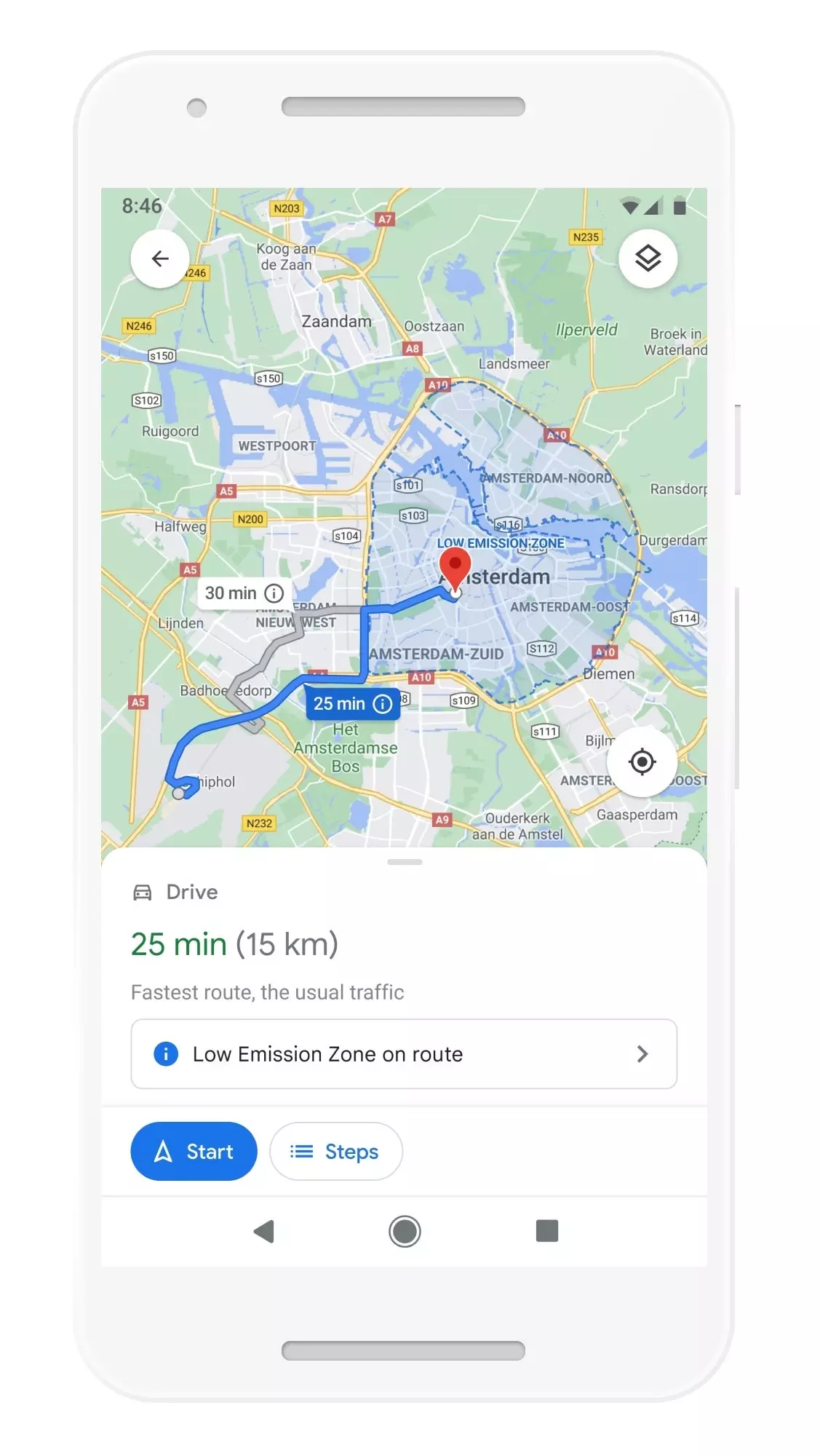
low emission zone
The ecological routes will launch in the US, on Android and iOS, later this year and little by little they will reach the whole world.
Cities like Amsterdam or Jakarta that have established zones in which the circulation of polluting vehicles is prohibited to reduce air pollution. To support these efforts, Google Maps will alert drivers when they enter one of these areas.
alerts from low emission zones will be released in June Germany, the Netherlands, France, Spain and the United Kingdom for Android and iOS.
And since environmentally friendly mobility is not just about cars, Google Maps will show a comprehensive view of all routes and modes of transport (car, public transport or bicycle) available for the chosen destination, automatically prioritizing the modes preferred by the user, as well as the most popular in your city.