
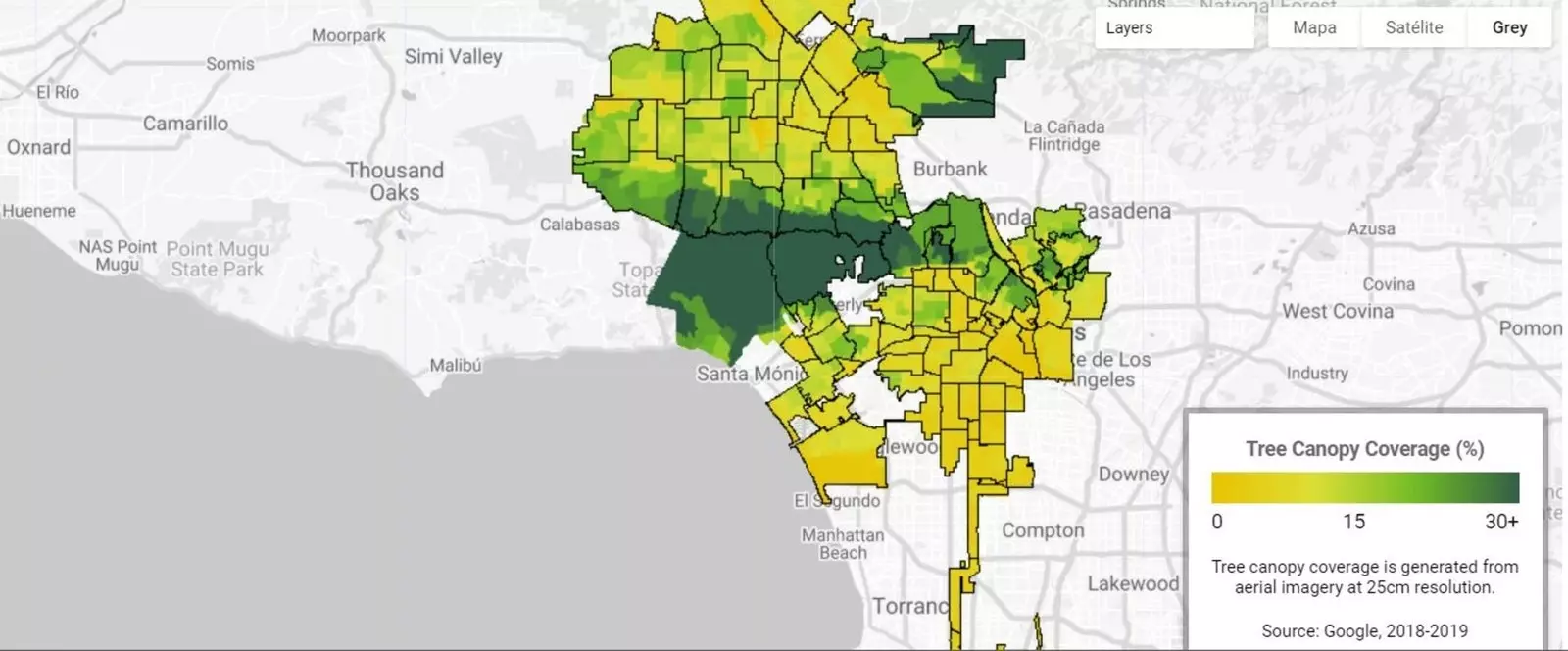
Labs: Tree Canopy, the map to replant trees in the city.
The global warming It is one of the main threats we face in the world. This summer we echoed the maximum heat figure in Death Valley in California. The desert became a land of fire with more than 54º of temperature.
The US is one of the countries where the most problems will arise in the world due to rising temperatures . Google knows this and has created Labs: Tree Canopy, a map with which it puts information at the service of cities to plant trees. This new tool has been launched in The Angels , in some of the poorest areas where there are fewer trees and where it is hotter in summer.
The heat island effect It affects precisely the neighbors who live in areas where there are no trees. Tree Canopy Lab found that more than half of Los Angeles residents live where trees shade less than 10% of the neighborhood . It also confirmed that 44% live in places with extreme heat risk. Considering that heat waves in Los Angeles have become longer and more intense in the last 50 years, the situation is practically unsustainable. This is confirmed by the study carried out by the NASA Jet Propulsion Laboratory.
And it is in these cases where the Google map is especially interesting because **it helps the city to know in detail in which areas it is necessary to replant trees. **
As stated on their website, the objective is "to develop policies and processes that highlight areas of high need for trees based on population data and risk of heat islands, and d develop long-term plans to plant more trees and ultimately reduce heat islands in cities.”
How do trees act? On the one hand they protect us from the sun (and also our buildings), and on the other hand they release moisture when temperatures rise. These two mechanisms can reduce summer high temperatures by as much as nine degrees Fahrenheit, according to the EPA.
The idea is that it will be applied later to new cities, in fact it can be the same governments or mayors who ask Google in a form for a scan to find out what they need for trees. In Los Angeles, a replanting figure has been set for 2021: 90,000 trees.
On the other hand, Google has also launched within the Environmental Insights Explorer project, Labs: Air Quality . This tool has started to be used in cities like Copenhagen and London where they have used mobile air sensors to map air pollution street by street, because as they say, pollution can vary a lot within the city.