
The southern highway, synonymous with adventure
Naming Patagonia in Chile is to name spaces without limits, infinite forests, nature in its purest state . Patagonia is a sonorous and beautiful toponym that encourages us to think of the last frontiers, of distance, of incomprehensible realities for a citizen of old Europe, where every square centimeter of the territory is used, populated, domesticated. In Patagonia, on the other hand, man is still a stranger and not even with all his strength and power has he yet managed, well into the 21st century, to tame and much less populate some places of disproportionate measures with young mountains, which are still in formation.
I think about it while I see the first frames of the great Chilean south appear through the window of the plane. The aircraft left Santiago very early and left me when it was still light in the morning in Temuco , the capital of the IX Region, about 670 kilometers south of the Chilean capital. From there a van takes me to Pucón (see Araucanía), an old logging town at the foot of the Villarrica volcano. Pucon is one of the most famous vacation centers in the Chilean Andes and the most touristic place in the Araucanía region, the prelude to Patagonia.
The silhouette of Villarrica volcano it fills the entire horizon of Pucón and its surroundings. It is a powerful volcano, perfect. A volcano from a book, or from a small child's drawing: truncated, lonely and isolated in the middle of the plain , with a smoking crater from which many nights flashes of fire come out of the incandescent lava and a perpetual snow glacier that shelters the summit like a scarf of ice. And below, a gigantic lake with blue waters bordered by black beaches of volcanic ash where you can bathe or fish. A paradise for lovers of the environment.
The Villarrica volcano, powerful and perfect
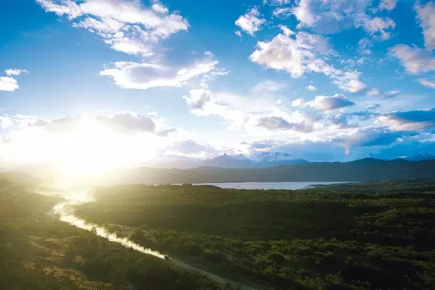
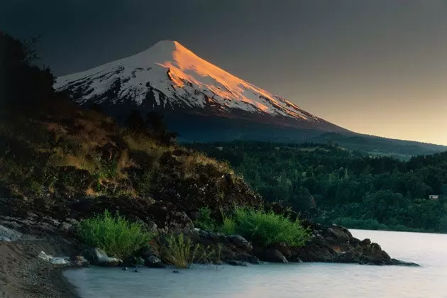
From Pucón I continue on the road to the south, always south . This is a country of extremes and the further you get from the center, the wilder the scenery becomes: desert in the far north; with forests, lakes and then glaciers in the extreme south. I pass by the Termas Geometricas de Coñairipe, one of the many thermal centers that take advantage of the emanations of hot waters that sprout on the slopes of the volcano, and after many hours of curves and crossing endless forests, I arrive in time to see the sunset in Puerto Varas. , on the shores of Lake Llanquihue, with another colossus of fire putting the perfect finishing touch to the setting: the Osorno volcano.
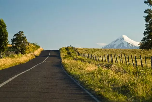
The road and the Osorno volcano
I'm in the lakes region , where the immense territory of Chilean Patagonia officially begins. Puerto Varas is the beginning of one of the best nature excursions that can be done through the Andean mountain range. For centuries, the Andes were an almost insurmountable border between Chile and Argentina.
Until the first roads were built, the only way to cross it was by looking for natural steps. One of the most frequented historically was the route that connects Puerto Montt and neighboring Puerto Varas , in Chile, with San Carlos de Bariloche, in Argentina, through the Todos los Santos and Frías lakes. It is what is called the Cruce de los Lagos, one of the most beautiful (and crowded, especially in high season) tourist routes in the Andes . But I do not deviate towards Argentina. Return to Puerto Montt to continue south through Chile. And to verify that if up to this point the Chilean geography was complex but predictable, beyond Puerto Montt, in the middle of Patagonia, everything becomes wilder.
The tectonic movements and the weight of the glaciers sank the earth's crust in this area; when the glaciers retreated the sea took their place. What was left was a extremely complex and intricate panorama of fjords, islands, sea inlets, channels and an inland sea that make it very difficult to progress by land. The typical image of Patagonia as a gigantic eternity of empty spaces where the howling of the wind can drive men crazy or trap them forever becomes a reality south of Puerto Montt.
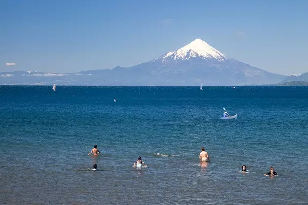
A group of bathers in Lake Llanquihue, Puerto Varas
The highest mountains were turned into islands. The largest of them is Chiloe , the second largest island in the American continent and one of the essential destinations in any visit to southern Chile. From Puerto Montt I follow the Pan-American highway for 59 kilometers to Pargua, where a ferry helps to cross the channel that separates the island from the mainland. Then I continue to Ancud, a fortified port founded by the Spanish in 1767.
During the colony, Chiloé was the tallow and wood pantry of the Viceroyalty of Peru, but the distance from Lima kept the settlers always in a precarious situation and in extreme poverty. The north coast of the island that faces the Pacific around the Lacuy peninsula is covered with dense forests that grow thanks to the humid currents that come from the ocean. It is an area of spectacular nature where there are many places of interest , among them the penguin colony of the Puñihuil islets, the only one in Chile where Humboldt and Magellanic penguins nest together.
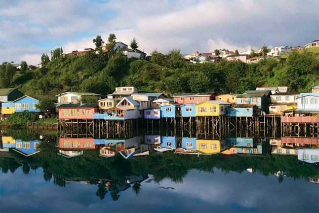
The picturesque stilt houses of Chiloé
All that coastal area facing the Pacific is protected under the figure of the Chiloé National Park, a green and fascinating territory covered by a forest of larches, coigües and olivillos . It is worth staying in one of the accommodations that the Huiliche communities, the original people of the island, offer in Chaquín or Huentemó and from there enter the trails of the park to discover some wild Patagonian landscapes where the force of nature is felt in every corner of its moist folds.
Through the continental area that is in front of the island of Chiloé runs the Austral highway, the great feat of Chilean engineering . Going through it to Villa O'Higgins, its southern end, is one of the great traveling adventures that can be done today in the Southern Cone. The first section crosses the so-called continental Chiloé, the most populated and domesticated area by humans. Even so It is home to some of the most spectacular primary forest areas in southern Chile. , such as those in the park Pumalin , between Caleta Gonzalo and Chaitén. Pumalín is famous not only for housing more than 300,000 hectares of genuine humid temperate forest that covers old glacial valleys.
Its celebrity also lies in the fact that it is the largest private natural park in the world. . In 1991, the American millionaire and philanthropist Douglas Tompkins bought 17,000 hectares of forest in this area just to leave it as it was and prevent their use or destruction. Little by little he was acquiring more land with the same ends: conserving it. In 2005 this private preserve of territory was declared a Sanctuary of Humanity. Tompkins ceded the land to a Chilean foundation that now manages it. The entrance to the park is free but you can only walk along the marked and authorized trails. The Carretera Austral advances towards the south overcoming all kinds of obstacles. Whoever ventures through it will find dozens of nature reserves and protected areas where the hand of man has not yet modified anything.
Wild Patagonia
Once past Chaitén, which is the capital of this province, we can turn inland, towards the mountains, in search of the palena lake , declared a national reserve. A semi-wild place, where the extreme rainfall (4,000 mm per year) maintains a dense forest of lengas and a humid environment and to a certain extent dark which makes us think of the titanic task of the first explorers of these areas just 100 years ago.
Back on the Carretera Austral, you pass through La Junta, a town at the confluence of the Palena and Rosselot rivers. Almost 30 kilometers further south of La Junta appears the access to the Queulat National Park , another of the inexcusable milestones. In Queulat, which unfolds around the Ventisquero sound, the temperate rain forest reappears in all its splendor, primary forest that man has not yet sullied. The star of the park is Hanging Ventisquero, a glacier that is born on the Alto Nevado hill, at an altitude of 2,225 meters , and whose front now forms a wall of ice hanging from a cliff from which a beautiful waterfall falls.
It is highly recommended the 3.5 kilometer trail that goes from the camping area to the glacier moraine . There are still many kilometers of Camino Longitudinal Austral, not always paved, and many more privileged natural spaces on both sides: the national reserve of the lake charlotte , the San Rafael Lagoon, the Corcovado National Park, the Cerro Castillo National Reserve… the road comes to an end –for now– in Villa O'Higgins, a colonization and border town that with its grid planimetry and its colored houses, it is the last human presence of considerable size before the great Southern Ice Field and the XII region of Magallanes begin, the southern border of Chile, a hieroglyph of islands, channels and fjords inaccessible by land.
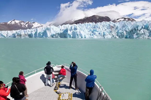
The San Rafael lagoon, which gives its name to a national park in the Aysén region
The few towns in this region, such as Puerto Natales or the capital, Punta Arenas, can only be accessed from Chile by boat or plane. To do it by land you have to cross to Argentina. Punta Arenas is the Chilean population that controls the northern shore of the Strait of Magellan. Despite its 130,000 inhabitants, it has something of a colonization post, a border city in which the light and the air presage the southern solitudes.
It reminds one point of Valparaíso, with those rolling hills covered with low, brightly colored houses that hang down to the shore of the Strait of Magellan. The local newspaper is called El penguin, more than enough reason to come to see a town as unique as this one. . Punta Arenas is the starting point for excursions to see nearby penguin colonies and areas of native forest in the Strait of Magellan, as well as cruises that reach Ushuaia through the Patagonian channels. Patagonia is one of the wildest, most complex and beautiful territories of the American continent. A territory still open to true adventure.
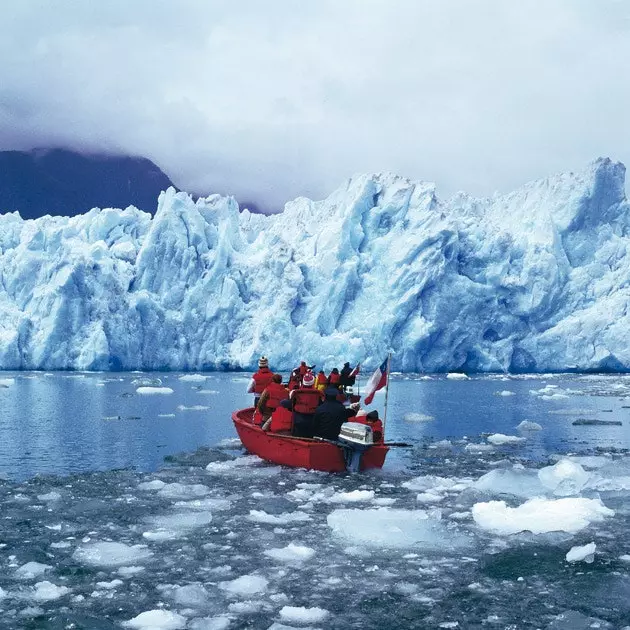
O'Higgins Glacier