
With shows like this, the asphalt can wait
In the vicinity of Rascafría, deep in the ** Sierra Norte de Madrid **, the Cascades of Purgatory they offer the opposite of what their pejorative name indicates: a peaceful excursion suitable for the whole family and possible in any season of the year, whose prize is to reach this capricious part of the Aguilón stream.
Bottle of water, nuts, sandwich, camera if the mobile phone is not worth it... Nor should you eat too much head when preparing the backpack for this excursion . Many also throw their professional hiking sticks, and there are even those who do it on horseback, but we will choose to use a fallen branch of those of a lifetime.
The path is feasible at any time of the year barring extreme weather conditions , so if you go in winter put on layers that you can keep in your backpack when you get warm, and if you go in the hot months take a swimsuit and a towel, there are very good bathing areas. And, of course, suitable footwear (mountain boots or sneakers), a hat (there is not much shade for much of the route) and sunglasses.
This treasure is located an hour and a half from the city
There are Mainly three ways to get there to this area of the ** Sierra de Guadarrama **, whose remote location will take us almost an hour and a half from Madrid capital: take the A-6 (road to La Coruña) and turn right onto the M-601 towards the Port of Navacerrada , do the same but go up the M-607 (Colmenar Viejo road), or take the A-1 (Burgos road) and turn left onto the M-604 direction Rascafría-Lozoya through the western part of the Community.
To suit the consumer, depending of course on the starting point: Google Maps is your friend.
Once in the municipality of Rascafría, we must go to the bathing area on the outskirts known as the loops (km. 28.6 of the M-604) and try to park as close as possible (in the summer months the car park in the bathing area opens for five euros). We will see car parks on both sides of the road, Needless to say, things get complicated on holidays and weekends (especially in spring and summer), So if we don't want stress, the options are to get up early or go on a daily basis.
Once the car is parked, we finally start our route on foot, which starts precisely in the bathing area of the loops , very close to the ** Monastery of El Paular .** It is the Lozoya River dammed at up to three different heights with grass areas and a beach bar on its banks, so if we find it open it will be difficult to resist the temptation to stay. But the rest of the year access is closed, so maybe it's the least intuitive and accessible site of the tour.
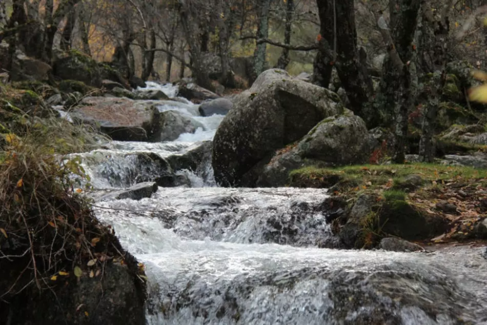
We have to get around the river area as best we can ** (jumping and using the dams, it is best to follow someone who knows it) ** until we reach the right bank. Once there, we take the forest road that leads to our goal, which runs mostly along the left bank of the Aguilón stream, a tributary of the Lozoya.
Another option is to start it directly from the Monastery crossing the water through the Bridge of Forgiveness, historic stone pontoon built in the 14th century. The truth is that there is not much loss, there is only a fork to the left about halfway and we will see indicative signs when they have to be. When in doubt, of course, asking is fine. The route has a total of 6.7 kilometers, with a drop of about 330 meters, and it will take us about an hour and a half to go up and a little less to go down. Pines, rowans, willows and hazelnut trees will delight our eyes as we pass, as well as an occasional herd of cows or sheep.
Excursions that end with gifts like this
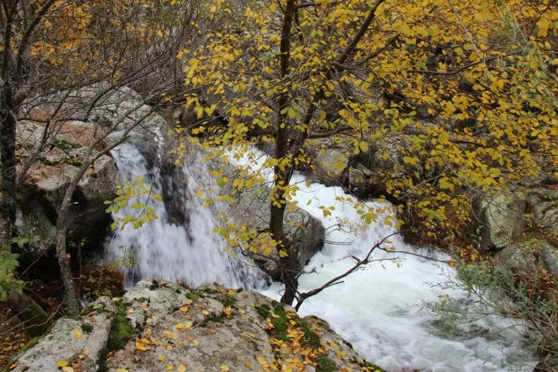
when we stay a little less than half an hour we will find that the path crosses the stream by a wooden bridge, making the last stretch along the right bank. Here now things get pretty bucolic, with green meadows on the shore of crystal clear waters, and many are content to arrive here. We must continue, since there is little left to cross the goal off the list. The terrain will get rockier and rockier. That's a good sign: we're getting there.
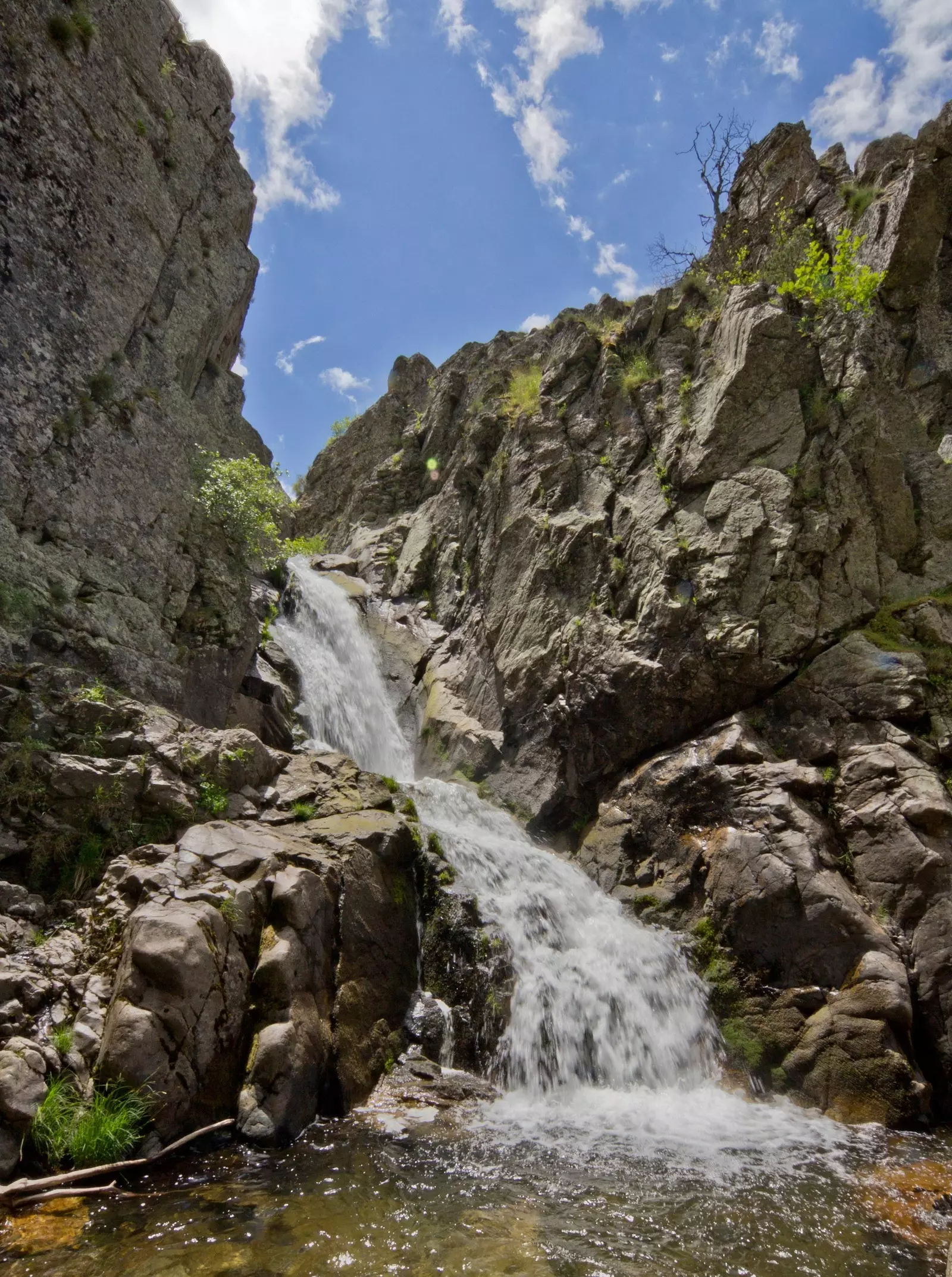
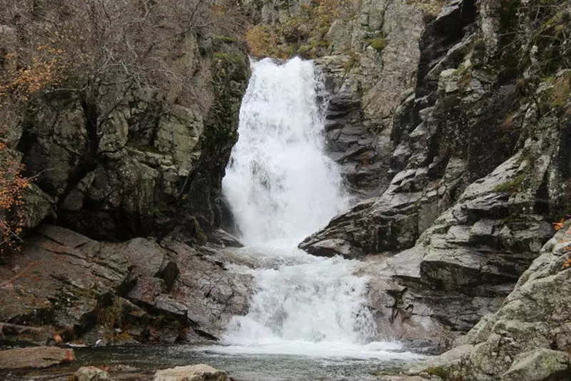
At the end, a narrow corridor will take us to a fenced wooden platform that serves as a viewpoint: We are already in front of the Cascadas del Purgatorio. the priceless gable view making its way through the rock, adorned by trees born in impossible places, will make it worthwhile.
If we go in high season we will have just enough time to take the required photo and make way for the following walkers, but nevertheless we can go along and/or venture up the rock if we want to enjoy the views for a while longer.
Actually we are before the waterfall falls, 10 meter jump , existing 200 meters upriver the high waterfall, 15 meters , but its access is much more complicated and it is advisable to leave it to the most experienced mountaineers.
We can also plant ourselves there to eat the sandwich (or take a bath in its cold waters if time and courage allow it), but the place is narrow and offers neither the comforts nor the sun that there is little below, so we opted to retrace our steps until we found a warmer place to dip our toes in the water while we eat our snacks.
We have about another hour and a half of descent ahead of us, so it doesn't take long to start our return, retracing the path to the car. We return with the satisfaction of a job well done and well-charged batteries.
In low season, the show can be seen (almost) alone