
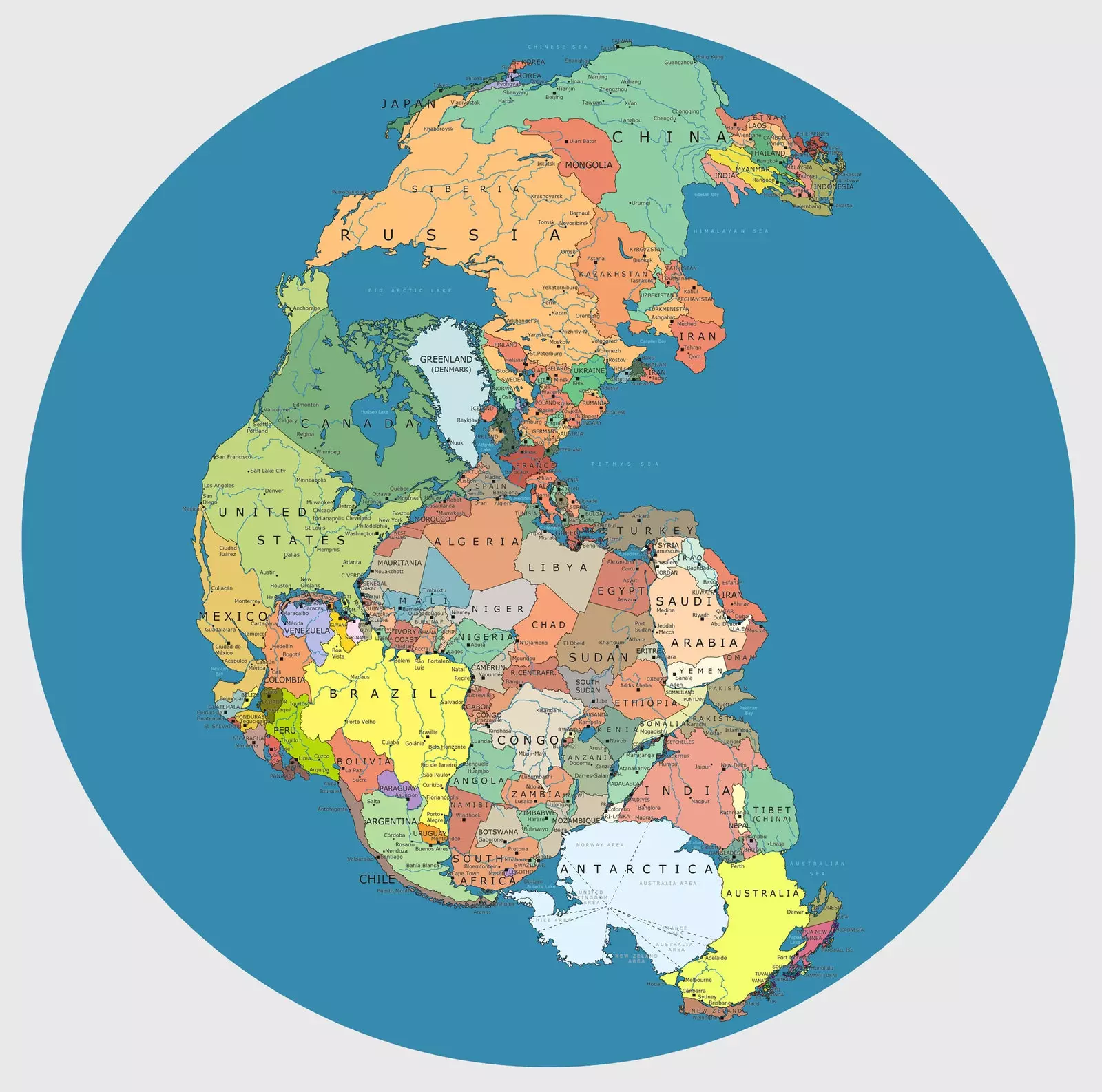
Political Pangea
More than 300 million years ago, the continents were joined by the movement of tectonic plates to form one. This super continent was called Pangea.
The term Pangea, used by Alfred Wegener, main author of the theory of continental drift, comes from the Greek pan (everything) and gea (earth). And indeed, it was a mass of land distributed across the equator.
One hundred million years later, Pangea was fragmented and the lands were moving until reaching the current location of the five continents, in a process that has not yet stopped.
Can you imagine what the world would be like if the earth had not separated? That's exactly what was asked Massimo Pietrobon and to answer the question he has created the map Political Pangea , which shows what our planet would be like if Pangea continued to exist.
Political Pangea, a map to reflect on
EXPERIMENTAL GEOGRAPHY
Massimo Pietrobon, An Italian who has lived in Barcelona for ten years, he has always shown a great passion for geography.
“I lived three years in Brazil, one in Morocco, two in sub-Saharan Africa –Between Sierra Leone, Angola, Mozambique, Tanzania...– in short, I like to travel”, Massimo tells Traveler.es
Massimo is an architect and currently works as an interpreter, illustrator and in graphic design, "My creative and restless side combines better with these disciplines," he says.
Many of his graphic works are related to geography. He declares himself a lover of maps and cartography but above all, he loves to subvert traditional worldviews.
“If the strength of each map is to intuitively visualize a reading of the world, filtering all its infinite complexity and transforming our surroundings into something clear and understandable, it is essential to use maps to expand our vision of the world, reverse it, transmute it... create visual clashes that question our stereotyped vision of what surrounds us”, comments Massimo.
From one of his projects he decided to use the maxi-continent Pangea to represent a time when the world was united and where distant and contrasting lands (in our eyes) touched and bordered each other with great fluidity.
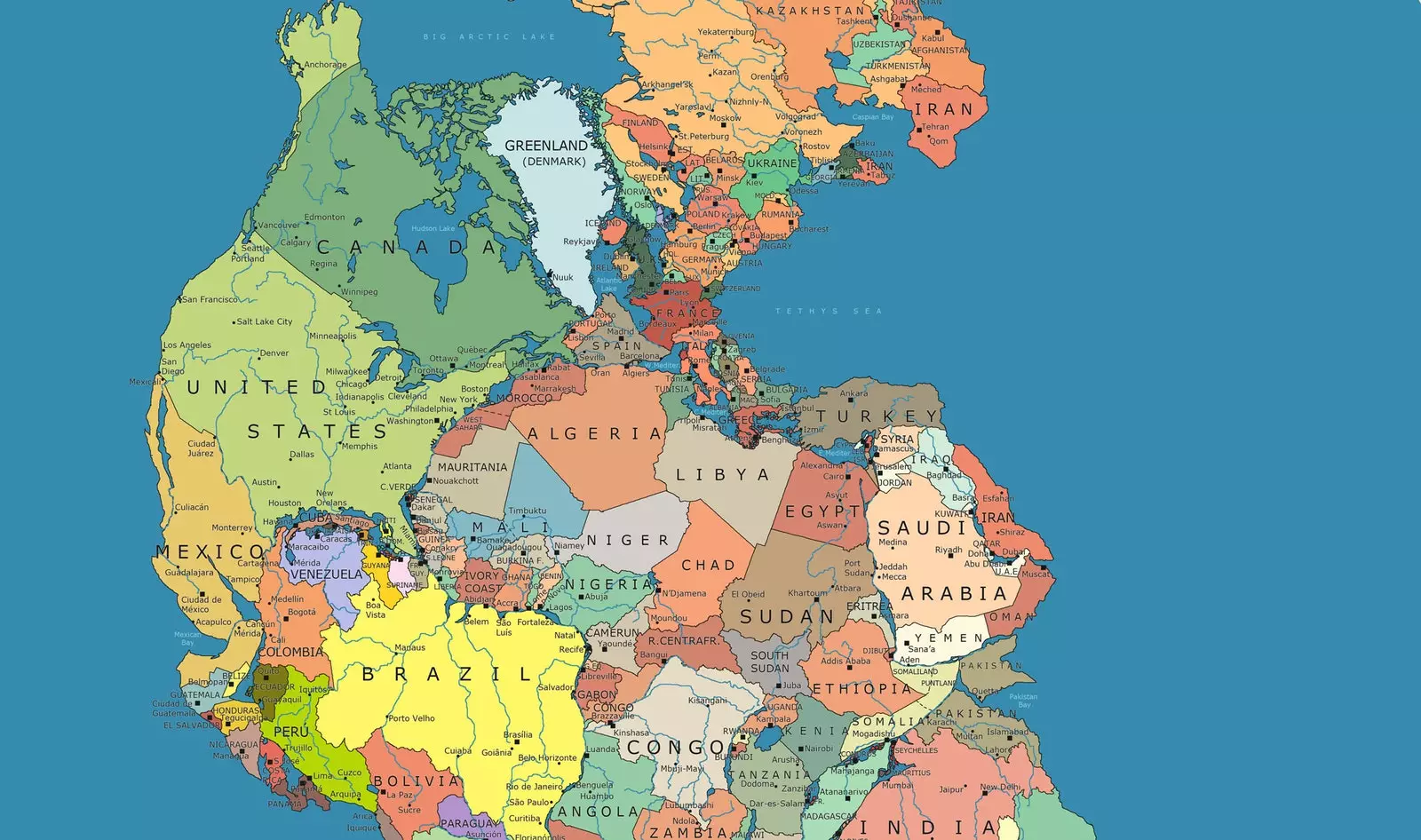
Spain and its neighbors
THE WORLD IS ONE
“If we look at a political map of the world, we think that we are only seeing the administrative divisions of our planet, but if suddenly Mauritania is touching New York, Antarctica joins India and Australia, we can realize how much hidden information we are carrying below the borders of the world”, explains Massimo.
The purpose of the map is to convey a message of unity: “We go on believing, without clearly perceiving it, that the world is divided into opposing blocks, impermeable to each other. At the base of Pangea Politics is the intention to break with all these ideas”.
“Thus, a clash of conceptual blocks is created which, in addition to being ‘revolutionary’ geographically speaking, It is based on a period in the evolution of our planet that actually existed." continues explaining Massimo.
It is interesting even in scientific terms, although the purpose is more artistic than scientific, explains Pietrobon.
In order to put all the current countries on a recognizable map, he has had to force some historical inaccuracies. The scientific reconstruction is generally correct, but let's say with a little license.
“What is important is that the graphic force and the main message pass through: the world is one, humanity is one. The divisions that they put in our heads are fictitious and artificial”, says Massimo.
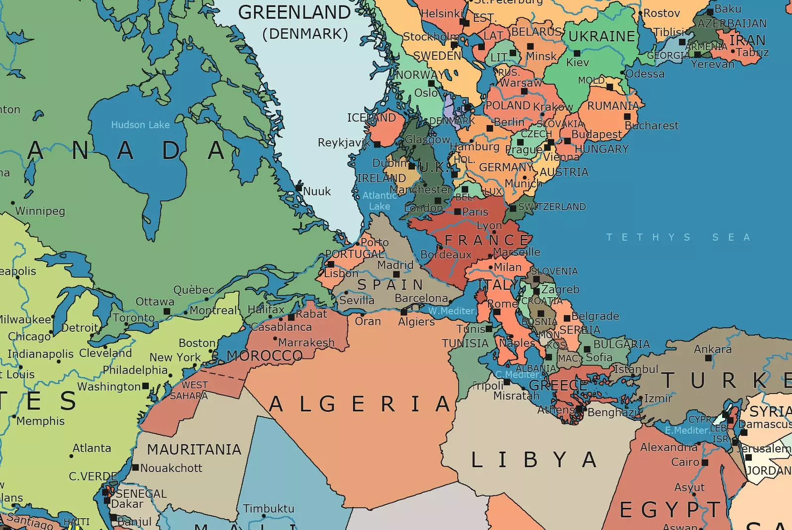
What would Europe be like if we lived in Pangea?
WHO WOULD BE OUR NEIGHBORS?
In addition to Portugal and France, if we lived in Pangea we could walk across countries like Canada, Morocco, Algeria or Greenland.
The Atlantic Ocean would be reduced to a small portion of water renamed 'Atlantic Lake' that would separate us from the UK and Ireland.
Residents of Australia, India, Sri Lanka, Madagascar, South Africa, Mozambique, and southern Argentina and Chile could leave excursion to Antarctica whenever they wanted.
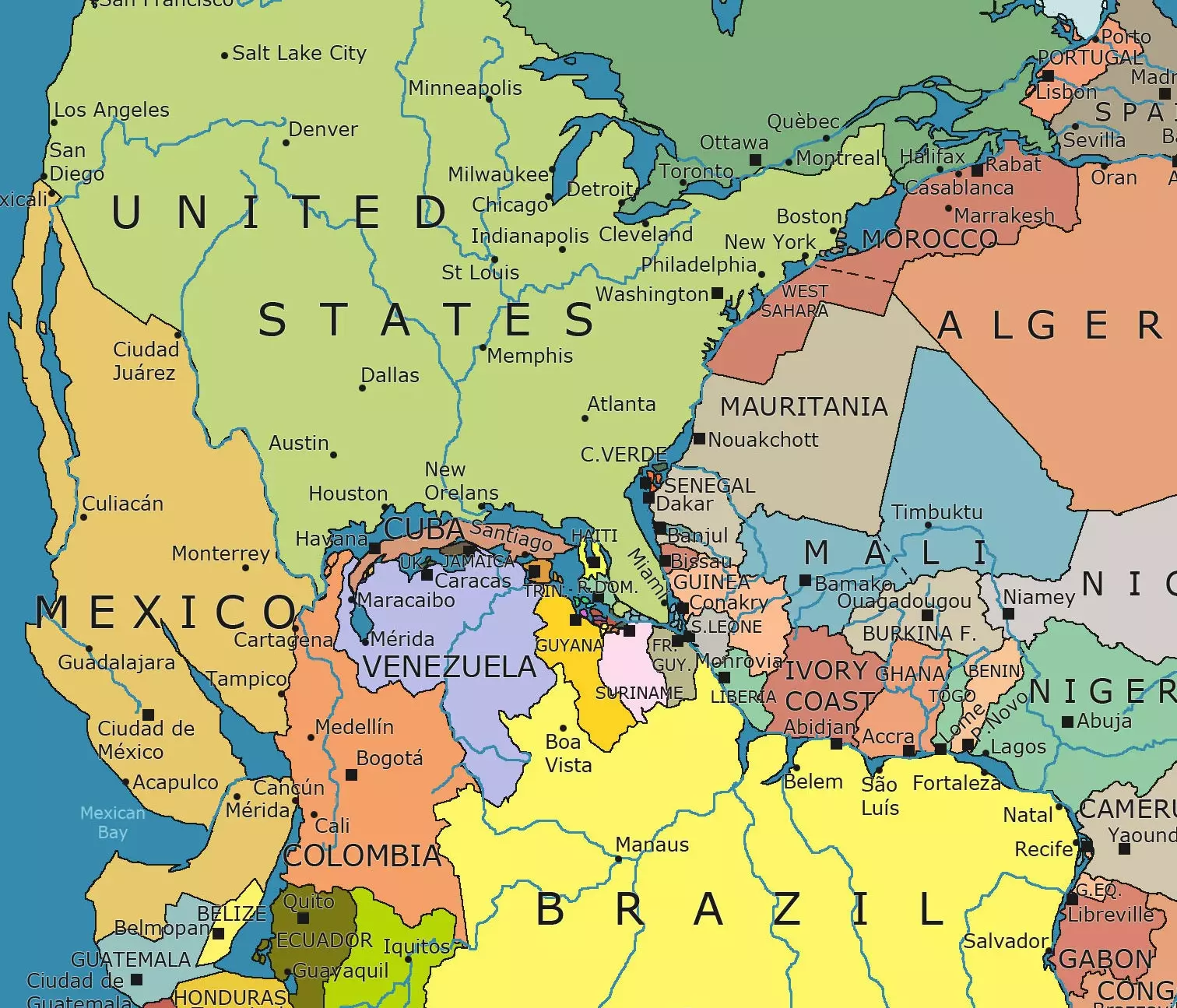
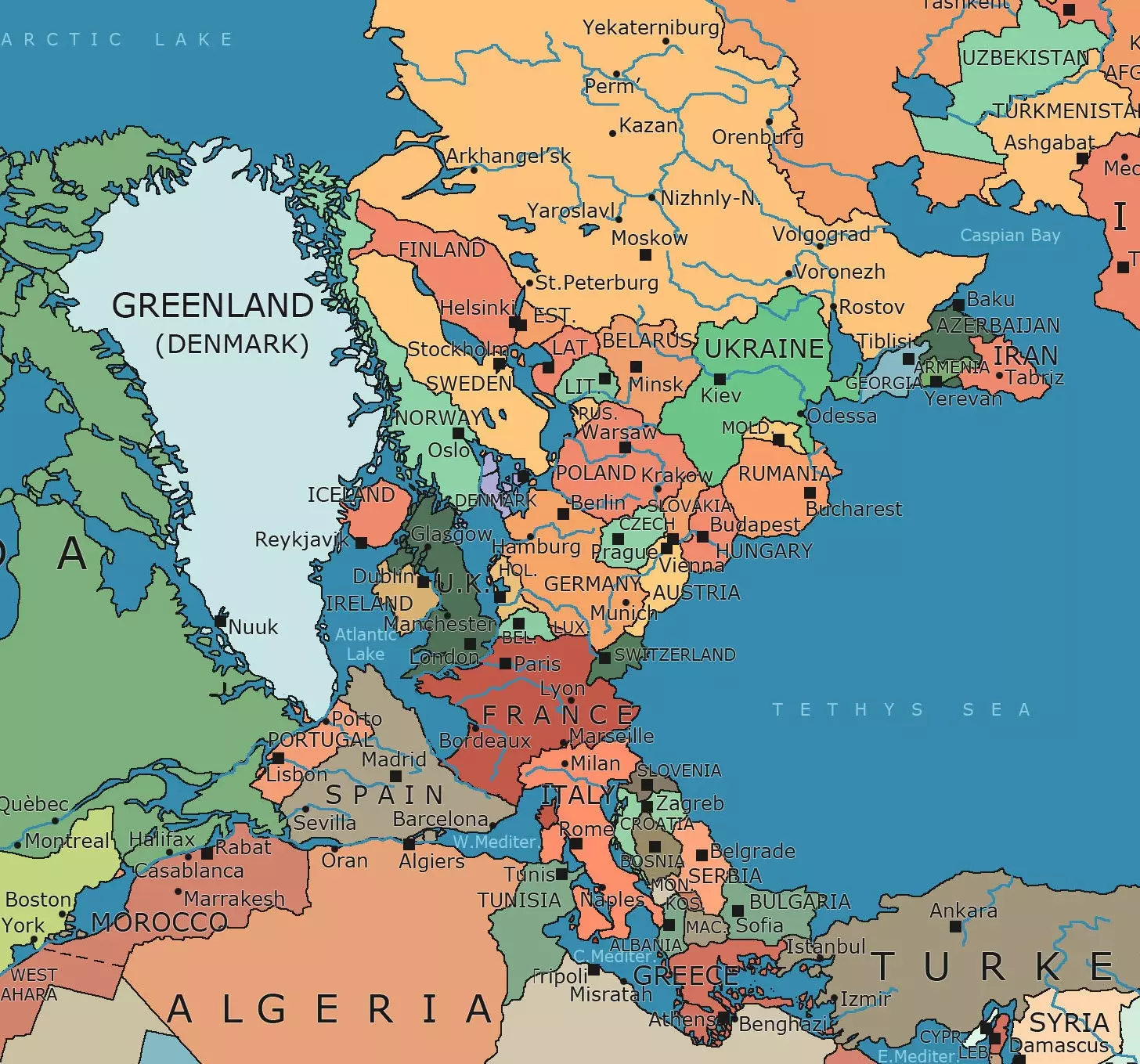
America in Pangea
MAPS EVERYWHERE
Maps, maps and more maps… Massimo's creativity and imagination have no limits. In his blog we can see, for example, a comparison between the sizes of Italy and Greenland or a three-dimensional globe of Political Pangea made in collaboration with Bellerby & co.
It is also very interesting this map of Spain in which we are shown which are the states whose population is equal to that of each of the Autonomous Communities.
Your latest project? "In the coming weeks I am going to make a 4 x 4 meter work of mixed technique between paint and recycled material that will be visible in a room at the HP center in Sant Cugat".
We will follow you closely!
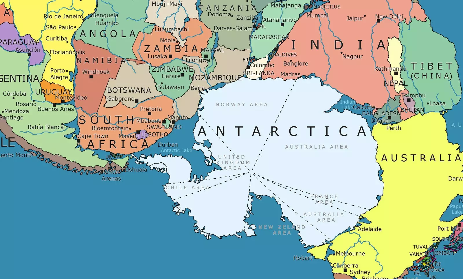
Taking a trip to Antarctica?