
Bill a maori legend that , in the heart of the North Island of New Zealand, there was a fire and lava fight between two volcanoes. The giants Tongariro and Taranaki they fought for days for the love of the beautiful Pihanga until the final defeat of the young Taranaki. This, according to tradition, took his feet off the ground and, full of sadness, he left the place towards the setting sun, giving rise with his tears to the Whanganui river. Exhausted, Taranaki rested, at last, in the last corner he found to the west of the island.
If we look at a map of New Zealand we can intuit the Taranaki exodus by tracing a line between both volcanoes. There, in its center, we will find the Whanganui and, not far from its bed, one of the routes most enigmatic of the Earth: the Forgotten World Highway or New Zealand State Highway 43.
The legend says nothing about that Forgotten World, but New Zealand's route 43 accumulates stories as striking and stormy as the Maori story. Stories like the town that was inspired by Shakespeare, the village that proclaimed itself a republic, the river that was declared a person or the lonely grave of man who died designing his layout.
Stratford, New Zealand.
STRATFORD, SHAKESPEARE NEXT TO THE VOLCANO
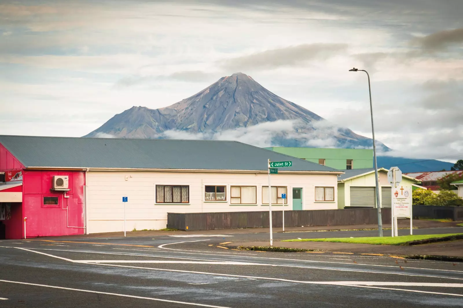
The inhabitants of Stratford wake up each morning with the watchful gaze of the defeated Taranaki. Located just 20 kilometers away, its imposing presence –it is the second largest volcano in the country– has become a daily habit. However, this volcanic proximity is not what makes Stratford unique, but the omnipresence in its urban planning of the most important English author in history: William Shakespeare . The place name Stratford comes from Stratford-upon-Avon, the writer's birthplace. In fact, the first version was Stratford-upon-Patea, in relation to the nearby Patea river.
Stratford, Forgotten World Highway.
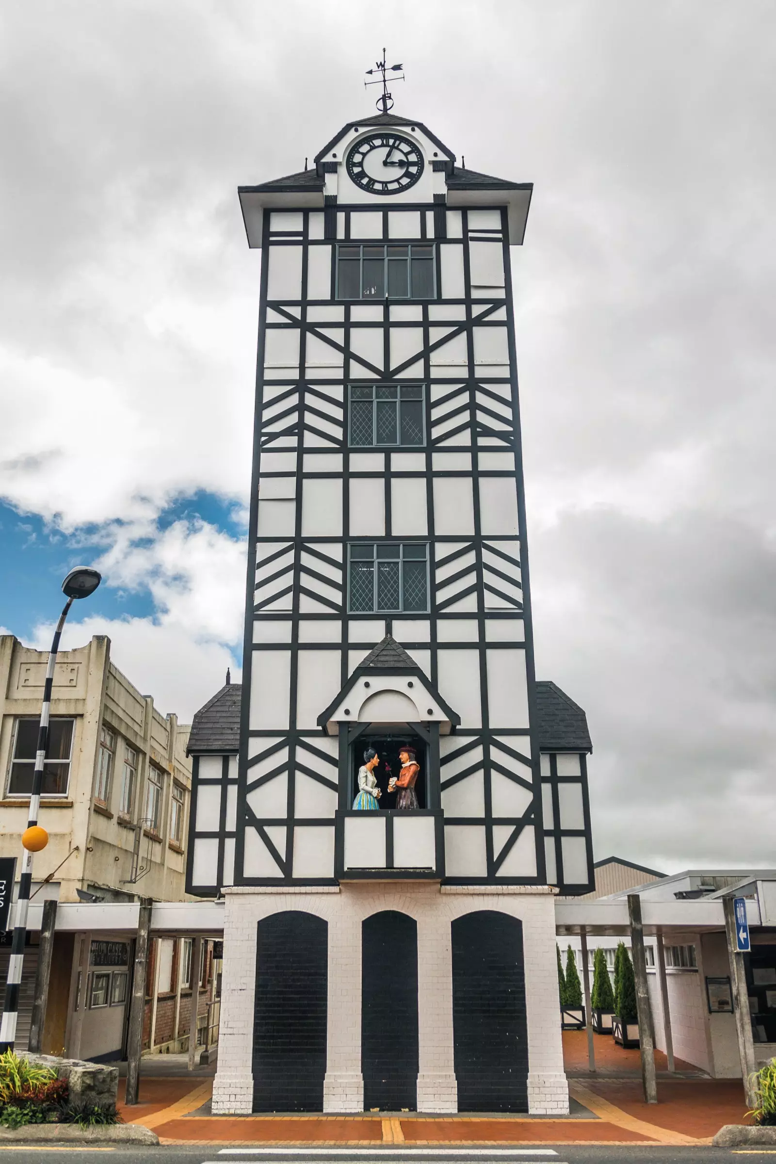
But the Shakespeare connection doesn't end there: up to 67 streets are named after characters from his works and, in its chime clock tower – the only one in New Zealand – Romeo and Juliet perform the balcony scene three times a day. In this way, in a distracted wandering, we find Fenton, Hamlet, Macbeth, Lear or the aforementioned Romeo and Juliet, whose tragic fate is also reflected on the map: perpendicular to each other, Juliet approaches Romeo to, just one street before their meeting, deviate without ever crossing.
Continuing with the literary-cartographic parallelism, Regan Street, the Machiavellian middle daughter of King Lear, She ends up dying, hungry for power, just like in the play: turned into a highway, from her ashes the 151-kilometre route that connects Stratford with Taumaranui is born, one of the few communication routes in this region with the center of the north island and, at the same time, one of the least used due to its tortuous layout: the Forgotten World Highway.
Forgotten World Highway, New Zealand.
IN SEARCH OF THE ROAD TO THE FORGOTTEN WORLD
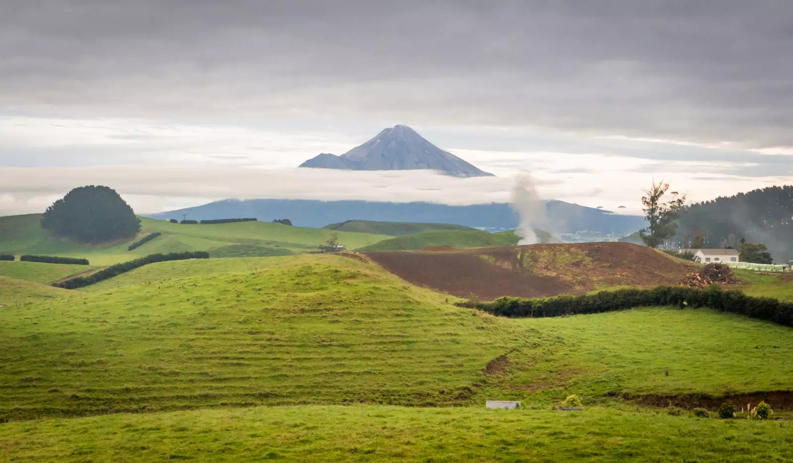
From a practical point of view, there would be no reason to travel the Forgotten World Highway. If we use a map, we will see that it is the shortest route between Taranaki and the heart of the North Island. However, this is misleading: built in the 19th century on the old paths equestrian open by European settlers, its layout, pregnant with curves, tunnels, bridges, hills and even a section of 12 kilometers unpaved, it is more reminiscent of nineteenth-century carts than a 21st-century road.
Fortunately, not all decisions are made for practicality. On the way out of Stratford, a road sign acts as an –exciting– prologue: Forgotten World Highway begins. "The game begins," it seems to say. As the plain of the volcanic ring is abandoned, the terrain acquires undulating shapes. Small hills reminiscent of the Hobbitton of The Lord of the rings flood the landscape and, parallel to the road, a train track in a zombie state zigzags and dodges as best it can the multiple obstacles.
Forgotten World Highway, New Zealand.
On the first stretch of road, the one that connects Stratford with the bizarre Whangamomona, three great elevations put in trouble to the inexperienced rider: the Strathmore saddle, the Pokohura saddle, and the Whangamomona saddle. The first two allow a clear view of the panorama, a fact that reveals the human presence in the territory: those bare hills, so attractive to the eye, are, in reality, headless Beauty, result of the deforestation of the first settlers.
After Pokohura, the prairie gives way to primeval forest and, already in the Whangamomona saddle, the native flora, dense and compact, suffocates all land space. Engulfed by vegetation, an information poster explains that this part of the road was completed in 1897, allowing the definitive connection between S Tratford and Whangamomona, the town that, a century later, would have one of the strangest aldermen of history
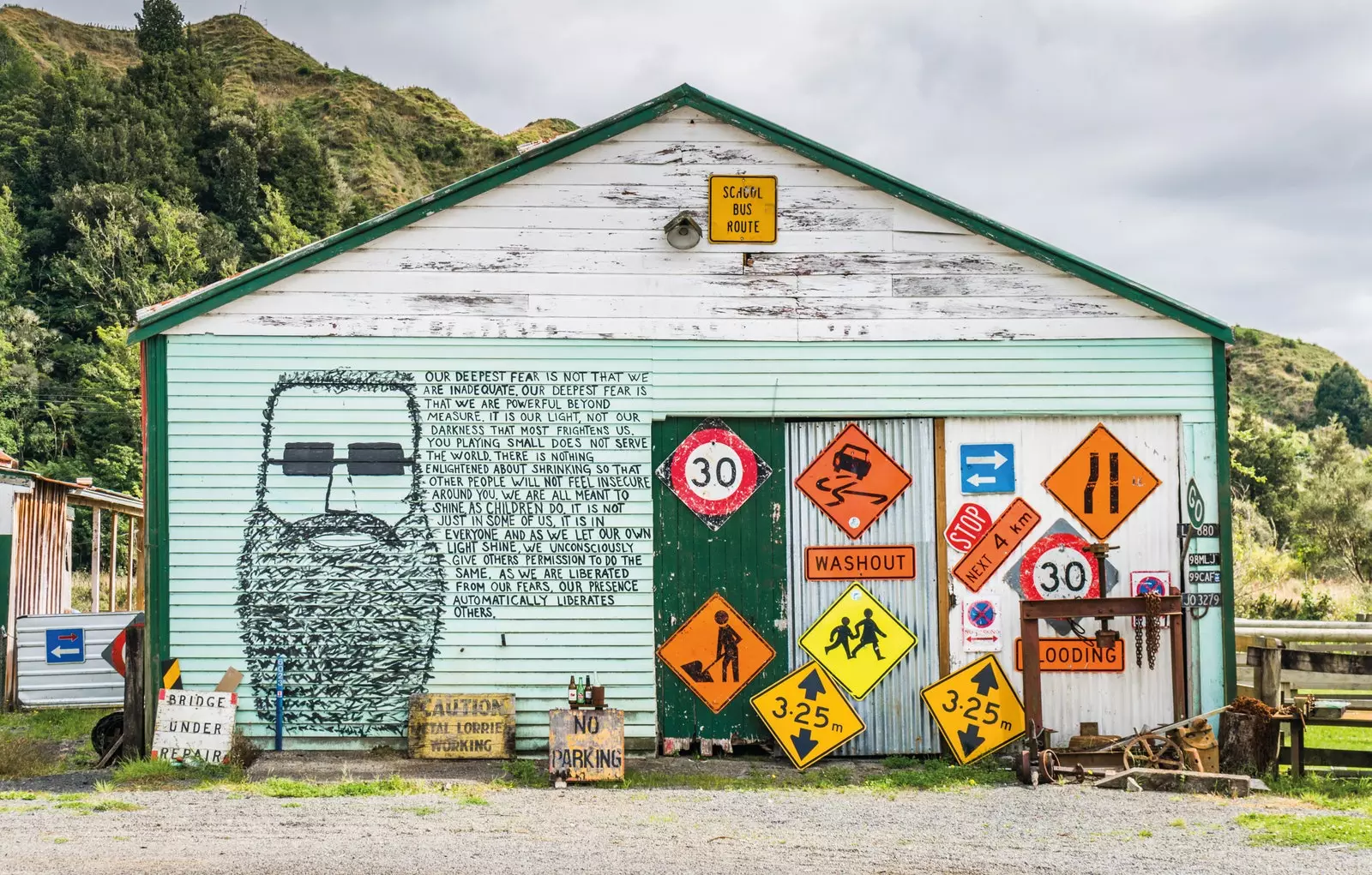
One of the facades of the disconcerting town-republic of Whangamomona, New Zealand.
WHANGAMOMONA, THE TOWN THAT BECAME A REPUBLIC
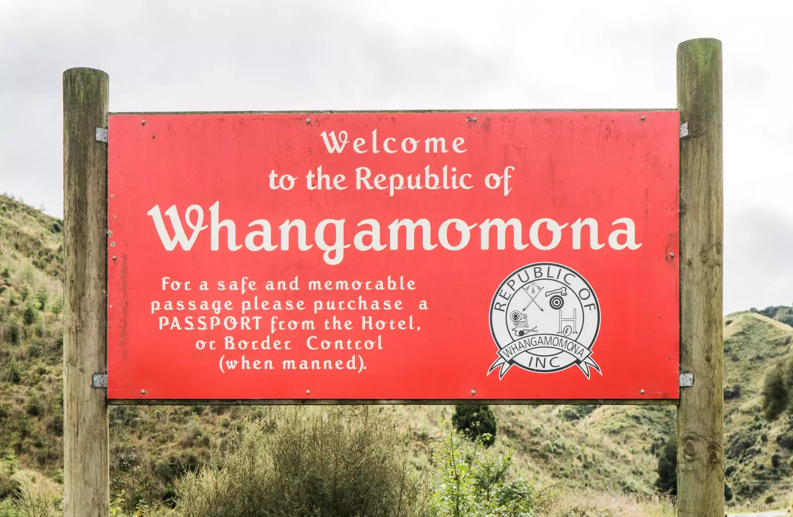
Billy Gumboot, the second president of the Republic of Whangamomona, he did not make a single move during his 18-month term. She didn't even utter a single word. And it is that Billy Gumboot was a goat, possibly the first elected animal in history. This piece of information, worthy of Monty Python, is more relevant than it seems since it is linked to a fact that saved the people from ruin: its proclamation as an independent republic. But let's start from the beginning.
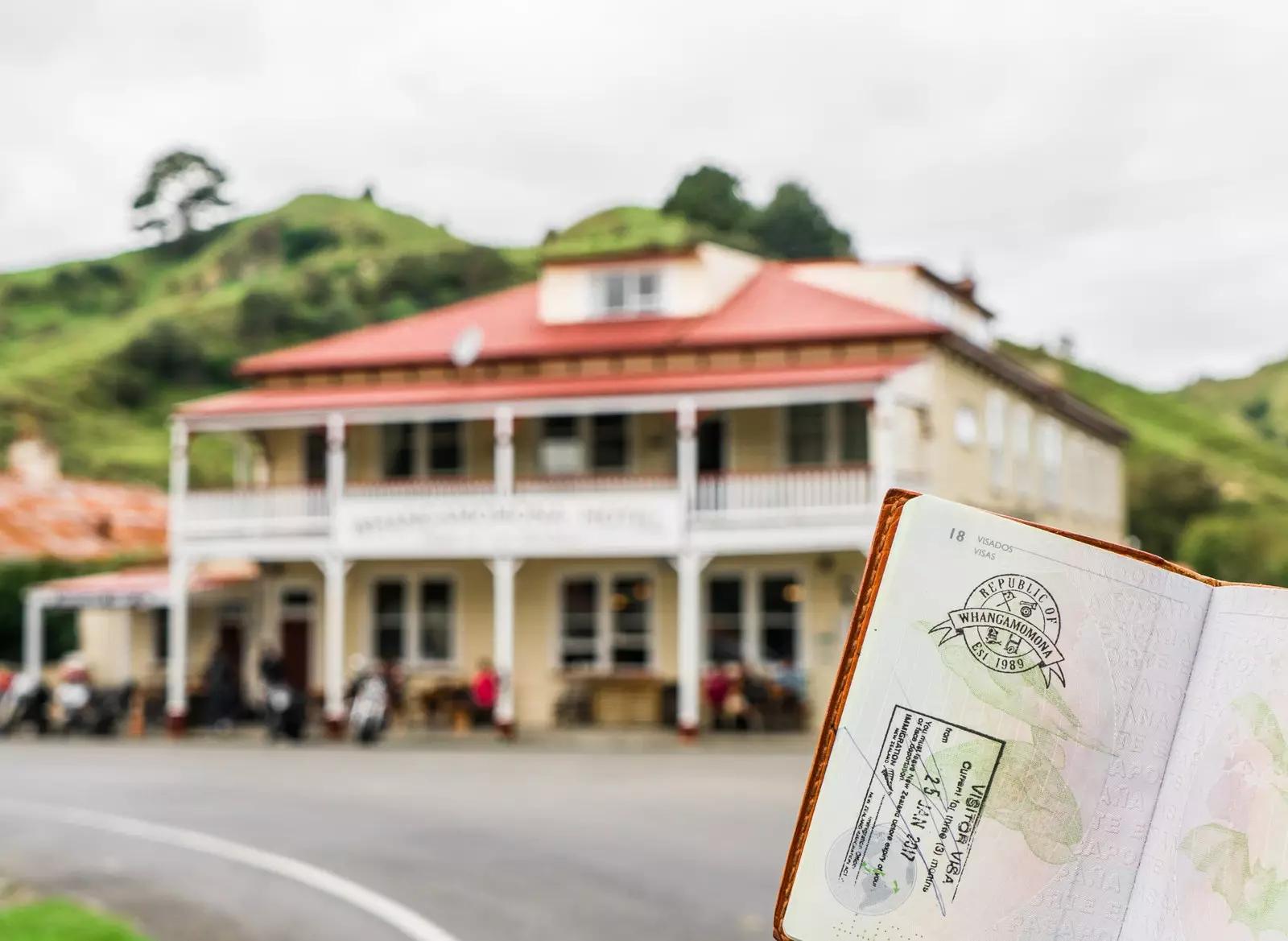
Life in Whangamomona was never easy. Founded in 1895, the town was on the verge of disappearing after the First World War, where a large part of its population died. The arrival of the railway (1933) and electricity (1959) caused an impulse for local growth, but this declined again with the closing of the school and the post office in 1988. When it seemed that the town was doomed to extinction, The event that changed everything occurred: the New Zealand government modified the territoriality of Whangamomona without consulting its inhabitants. These, by way of protest, They proclaimed themselves a republic on November 1, 1989. The proclamation of independence – more fictitious than real – had such an impact that it attracted the press from all over the world.
Since then, six presidents, among them a goat, a poodle and a tortoise, have succeeded each other in the mandate of a republic that celebrates a great festival every two years, on January 21. This has caused the influx of tourism whose main objective is to stamp your passport with the emblem of the Republic, for sale for NZD 2 at the hotel-bar-government. However, there were places that were not as lucky as Whangamomona.
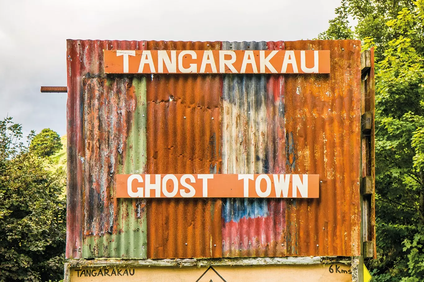
Tangarakau, Forgotten World Highway.
TANGARAKAU: GLORY AND FALL OF A GHOST TOWN
Several miles from Whangamomona is Tangarakau, once the second largest town in the region and of which only a few crumbs remain today. Tangarakau was the central nucleus of the construction of the railway between Stratford and Okahukura, in the 1920s and, after the opening of a coal mine, the population reached two thousand inhabitants in the early thirties. Nevertheless, in 1936, with the abandonment of the mine, the decline began that would end with the closure of the school in 1959. Without a declaration of Independence that has acted as a resuscitator, today, Tangarakau has become a ghost town near what is possibly the wildest space on the entire Forgotten World Highway: the Tangarakau Gorge Nature Reserve, the place where the man who laid out the road lies buried.
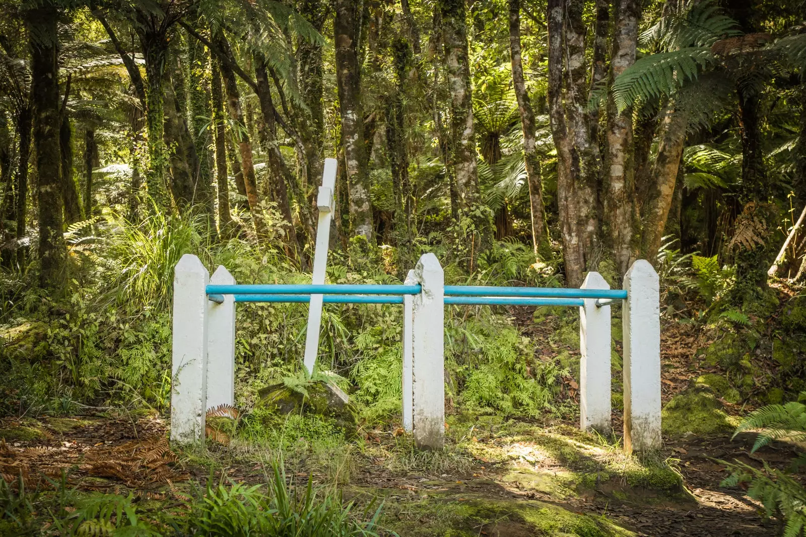
Joshua Morgan's grave, Forgotten World Highway.
JOSHUA MORGAN, THE TOMB OF THE FALLEN HERO
Many of those who cross the Road to the Forgotten World ignore it, but a few meters from it is the grave of the man who gave birth to it. Until 1935, the road from Tangarakau was difficult to overcome because of the hill called Moki saddle. It was then that the construction of the Moki tunnel was carried out, renamed years later as Hobbit's Hole. your construction project dates back to the 1890s and it was devised by one of the great protagonists of the Road to the Forgotten World: Joshua Morgan.
Born in the mid-nineteenth century, Joshua Morgan was an experienced surveyor that, after the birth of his first daughter, in 1891, he decided to abandon surveying. However, after a short time, the project manager for the Stratford-Taumaranui route asked for his help. Morgan accepted the challenge, which he met with no problem until he reached the Tangarakau River in late 1892, where he found it difficult to find a layout that would overcome the mountainous system of the area. It was there that, in February 1893, he began to suffer from severe abdominal pain. Some team members they left in search of medicine, using several days for it. None had any effect. Since it was impossible to transport Morgan, a new team set out for more help, but to no avail; upon his return, Morgan had already passed away.
His body was buried near the bridge between the Tangarakau river and the Paparata stream, in a small clearing where, even today, one can see the white cross who raised his companions. The bridge where Morgan lies is the place where the only unpaved section of the route begins (waiting for the start of some works that never arrive), located in the Tangarakau Gorge Nature Reserve: 12 kilometers of gravel embedded in native forest and walls over 50 meters high. When the asphalt returns under the wheels, the hills, once lush, once again show off that sheared sheep look of the initial section. The terrain, although winding, becomes less and less abrupt and a new watercourse appears on stage: the Whanganui River, the tears of the defeated Taranaki, also known as the river-man.
Forgotten World Highway, New Zealand.
WHANGANUI, THE RIVER MAN
The ancestors are everything for a Maori and, among them, Not only human beings are counted: New Zealand natives also identify themselves as descendants of various natural entities such as mountains, forests or rivers. For the Maori tribe of the Whanganui, the homonymous river, born of Taranaki's sadness, is not only a river, but also one of its ancestors. This led to the fact that, in March 2017, a historical event happened in New Zealand: after more than 160 years of legal disputes, the tribe managed to get Parliament to pass a law that recognized the river as one of its ancestors, thus giving it the status of a legal person.
In this way, the last twenty kilometers of the Forgotten World Highway they run caressing the outline of a river that was born tear and now he is a person up to Taumaranui, “place of great refuge” in the Maori language. Taumaranui is both destination and shelter, the ideal place to digest all the stories collected on a route that, by dint of repeating his name, has become a legend. Like the that wounded volcano that looks towards the sunset ruminating revenge on him.
This report was published in the number 149 of Condé Nast Traveler Spain. Subscribe to the printed edition (€18.00, annual subscription, by calling 902 53 55 57 or from our website). The April issue of Condé Nast Traveler is available in its digital version to enjoy on your preferred device.