
What if instead of the metro you take the bike?
For those who have always moved around Madrid by bike, for those who are new to it, for those who want to (re)discover routes, for those who are going to open up to new neighborhoods and routes, for those who are used to cycling, but not cycling in this city... In short, the map of the capital that replaces the metro lines with itineraries to be done at the stroke of a pedal It is designed for anyone who wants to get around Madrid by bicycle.
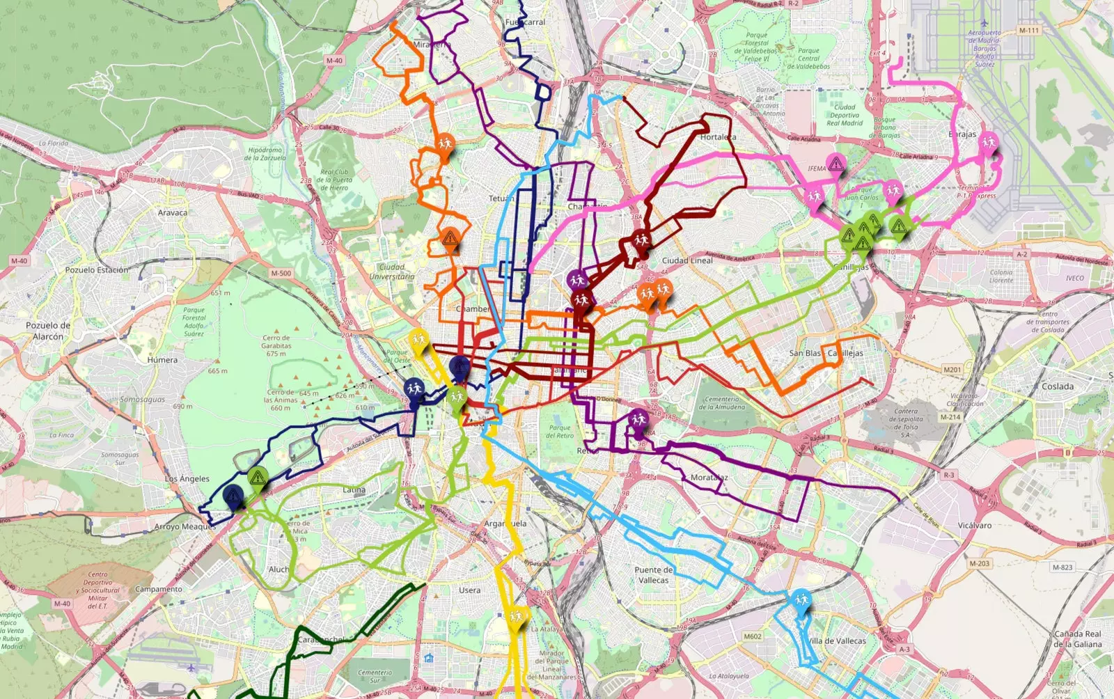
From lines 1 to 11, this map shows “a series of practical routes with which to be able to move from one point to another in the city by bicycle, being sure that it is a feasible route by bike”, explains to Traveler.es Henar Salas, one of its creators and an urban cyclist who has been cycling around Madrid for seven and a half years.

You think you know a lot about Madrid because you've walked it over and over again, but things change when she has to pedal through it
And it is that Madrid is big, quite big, and one can think that it controls it well because it has more than walked. Nevertheless, many times you travel by bike with the intention of traveling long distances that will take you out of that familiar area in which he knows where the forbidden senses are or the barriers to cross.
That's where this map comes in. "It serves to give information about those streets of our route that we do not know" and also the tranquility provided by having a first route in mind before starting to circulate.
Thus, starting from the idea that almost all of us have in our heads a Madrid scheme in which many times we use subway stops as a reference, This map was born and it did a little (or a lot) like good ideas are born: as something else, to go polishing and shaping.
"I had been thinking about it for a long time and these weeks I finally found some time to do UrbanBiciMap," says Henar, who brought together her profession, a geographer, and her two passions, cycling and maps, in this project in which she reflected 10 routes to stroll around Madrid by bike.
“When I was wearing two of them, Amelia, from Madrid Ciclista, proposed the idea of make a map based on the Metro network which could be hosted on the association's website. Then, most of the lines have been drawn by another member of the association, Juanma, that she has also corrected, along with others, the ones I have drawn myself”, she concludes.
The result is a map created with open source technology which works in layers. Thus, each metro line has been assigned two layers (one per direction) that can be made visible or invisible depending on whether they are of interest or not for each displacement. Apart from choosing the direction, the user can consult at the same time, as if he were in the subway and made a transfer, several lines and connect different points of the city.
In addition, there are always at least two alternatives. “One strolling through the streets and the other on the main roads because there are cyclists for all tastes, or one day you feel like one thing and another tomorrow. As both options share some sections, all the routes of the same metro line and direction are in the same layer", explains Henar.
The map includes indications on pedestrian sections, metro entrances, bike parking and Bicimad stops
"We also include indications when it is worth making a crossroads or a small section on foot, or which tunnels and viaducts we recommend and which ones we don't”. and locations of the Bicimad stops, bicycle parking lots and metro entrances.
HOW THE MAP WORKS
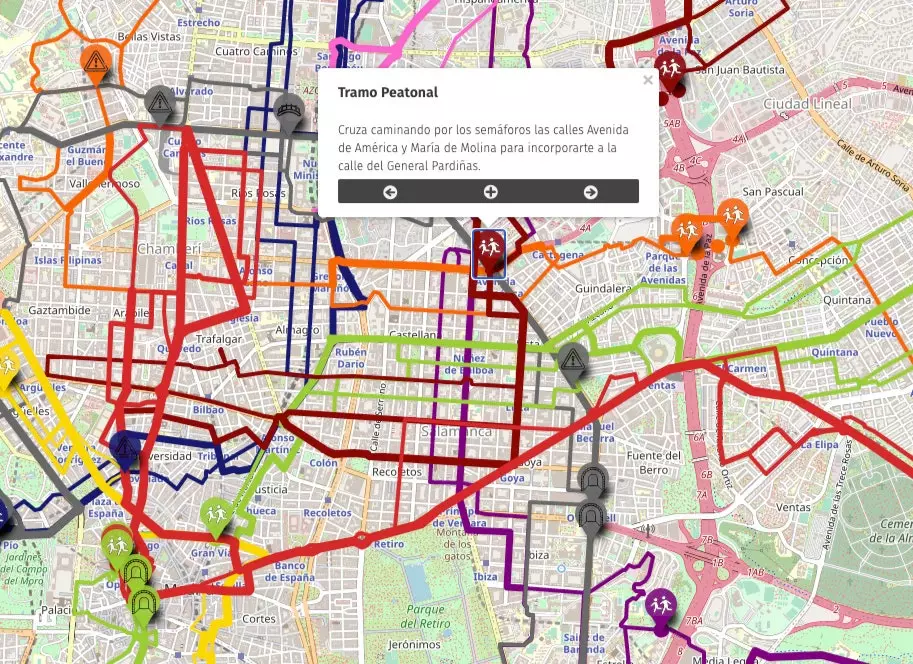
In the upper left corner of the map, we find the control commands: zoom, address search, full screen, share, center the map, the tool to measure distances, change the background map and layers.
“If from the subway map you sense the path you should follow, choose the layers of the lines and direction that you would take in the subway and zoom in to follow the path they mark. The thinnest lines indicate routes through the streets, perhaps with some detours or slopes and usually less traffic; and the thick lines mark sections of main streets, usually more direct. The best route is the one that best suits your tastes or desires for that day”, assures Henar.
“If there is a point where you must walk or any relevant notice, it is marked with a point. Click to see the warning or tip. If you already know the area, you will surely find an alternative that suits you better for your specific origin and destination, and also no need to move like the subway, You can drive down any street and avoid the subway detours. It is a guide that helps you design a feasible route.”

Urban cyclist tips for beginning urban cyclists
Urban cyclist tips for beginning urban cyclists. That is its other great attraction and what differentiates it from tools such as, for example, Google Maps that allows you to calculate the bike route. “They take you from one place to another, but sometimes they take you many meters in the wrong direction or through a park where there are a lot of pedestrians or even down stairs,” she reflects.
Henar, who arrived in Madrid as an adult, took a long time to get to know the streets and be able to move around the city without having to constantly consult the map. "To ride a bike I have gained a better understanding of the directions and turns allowed, types of streets in terms of amount of traffic, shade, slopes, etc. and now I no longer notice the insecurity that she felt at the beginning every time she wanted to go to a new place by bike”. That experience is what they now share with other cyclists.

Feeling of freedom, the possibility of feeling the breeze on your face, not depending on schedules or where to park... Advantages of getting around the city by bicycle
MORE RECOMMENDATIONS
It can give you vertigo. Starting to ride a bicycle in a city like Madrid. Therefore, Henar stresses the importance of respect traffic regulations, be visible using the center of the lane and avoid blind spots, and be predictable, signaling manoeuvres. "When you stop at a red light, still no one else passing, the car behind you understands that you follow the same rules."
She also remembers that in the city there is no minimum speed, so recommends circulating at the speed at which we feel comfortable. "The car will not care if you go 12 or 15 per hour, and for you, as a cyclist, trying to go very fast can tire you quickly."
She shares one last piece of advice that she learned as an instructor at the Women on Bike Workshop. “If one day they whistle you or tell you something for no reason, think of all the other drivers who have respected you and even yielded the right of way and facilitated circulation. When you put it on the scale, you immediately smile again.”

Cycling in the city gives you the same freedom as walking, but takes less than half the time
And it is that riding a bike in Madrid has its former, its little bit of difficulty. Mainly for the not knowing where to go, that can prevent you from focusing your full attention on the traffic and pedestrians around you; but also for peer pressure "of all the times they tell you that it is dangerous or that they remind you that you are brave, but those of us who ride bikes are normal and ordinary people, it has no special merit".
Although if we take into account the number of advantages that cycling has (for oneself and for society), perhaps they do have some merit. Feeling of freedom, the possibility of feeling the breeze on your face, not depending on schedules or where to park, the exercise that one does and that is good for both physical and mental health...
"The bike is the most efficient means of transport in the sense of energy used and distance traveled, and in the city it gives you the same freedom as walking but taking less than half the time”, reflects Henar. As far as economics is concerned, "there are studies that relate riding a bike with higher consumption on the way. with the bike It's not hard for me to stop for a moment in a neighborhood store on the way back or have a drink on a terrace. By car you would have to find parking for each stop.”