
The geological spectacle that is Las Tuerces
We all know the existence of Natural Parks, Biosphere Reserves and other protected spaces where biodiversity is preserved based on the protection of the territory. Geoparks, on the other hand, protect the orography, culture and geology of the places they encompass.
Geography, and what it encompasses, is the museum piece of a long series of spaces protected by UNESCO spread across the globe. Spain has fifteen geoparks, and one of them, perhaps the most mysterious, is the Geopark of Las Loras, located on horseback between Burgos and Palencia until touching the border with Cantabria.
Karst formations, tuffs, faults and sinkholes alternate with archaeological sites of Cantabrian forts and Roman camps. Prepare your torreznos and sit down to see the landscape: we enter the Geopark de las Loras.
PEÑA AMAYA (BURGOS)
The Peña Amaya (1,377 meters) breaks the horizontality of the plain like the figurehead of a ship facing the undulating swell. This rocky 'mill', made up of three levels of terraces culminating in a flat plateau, It is geologically a perfect example of a syncline and inverted relief, and historically, a natural fortress used by humans for millennia.
At its feet intersect the paths that join the coast and the Castilian plateau, and from its summit you can see the lands that the Forgotten Way of Santiago crosses. It is an incomparable hill for lovers of geography to enjoy the view of Cretaceous limestone and upper Cretaceous marl outcrops.
These rocks that now make up mountains were, 65 million years ago, part of the seabed: It is not uncommon to find fossils walking around Peña Amaya. Nor should we be surprised to find ourselves face to face with two huge stone jambs and the canvas torn down from a wall, Well, Peña Amaya was a city and fortress occupied at intervals by Cantabrians, Romans, Visigoths and Castilians.
Its impregnable position required seven Roman legions commanded by Emperor Augustus himself, to whom the tiresome campaign against the Cantabrians was worth a painful illness. And eight centuries later, they would be the Visigoths escaping north with Muslim armies hot on their heels who would climb to the top of Amaya, where they ended up surrendering due to hunger in the year 713.
PÁRAMO DE LA LORA (PALENCIA)
Peña Amaya is the gateway to the mountain and the Geopark, whose roads surround it to the east. Taking the BU-621 highway we can admire its colossal dimensions while we go into valleys embedded between 'loras', as the flat-topped mountains are known that continually break the landscape, like chipped teeth that devour the oatmeal-colored cake of the plain. Plains that, as we head north and after crossing the Lucio River in Quintanas, gradually disappear until giving way to the natural monument that gives its name to the Geopark: the Páramo de la Lora.
To understand the admiration that the solitudes of the moor have provoked since long ago, the visitor must take the winding road that begins in Pomar de Valdivia and ascend in search of the sky until the Cueva de los Franceses and the viewpoint of Valcabado.
It is likely that we will see roe deer grazing among the wheat fields, competing with the poppies for our attention. The fauna of the Geopark is as rich and varied as its geological formations and such emblematic species as the golden eagle or the Iberian wolf.
The presence of the second will come to our mind when we start walking through the rough and lonely moor, with no horizon other than the mountains that surround us: civilization disappears as we move away from the lookout and, before we realize it, we will have lost contact with the outside world.
Formed by hard limestone that makes the soil a wasteland, The moor has been forgotten by how many generations have lived within the limits of the Geopark. home of shepherds, maquis, fugitives and hunters, It housed oil fields that can still be visited and in modern times it has been converted into a place harnessed by science. The Astronomical Observatory of Cantabria is located on the cliffs of the moor, an ideal place to observe the sky due to the cleanliness of its atmosphere.
The wind fields they are the only symbol of humanity that breaks the wasteland: the rest is wind, weeds, horizon and silence.
THE EBRO RIVER CANYON (BURGOS)
The monotony of the moor is suddenly interrupted to the east of the Geopark. The Ebro river, young and vigorous, tears apart the limestone of the Kemp's ridley in its tireless search for the sea, shaping a geographic feature out of a western: the Ebro canyon.
Of climate and relief much more benign than the moor, the canyon is home to postcard towns such as Orbaneja del Castillo and Tubilla del Agua, raised next to enormous cascades of crystalline waters called tobas.
Every liquid element that springs from the walls of the Ebro canyon, giving its fauna and its peoples a drink, comes from the moor, confirming that even the worst desert can give rise to the vegetal beauty that treasures the bottom of the canyon.
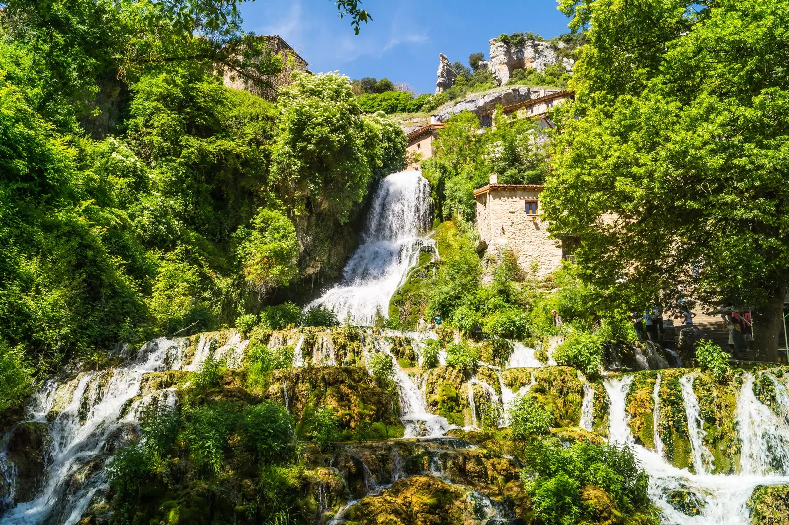
We have found the most beautiful town in Burgos: Orbaneja del Castillo
MOUNT BERNORIO (PALENCIA)
It is a recommendable option to leave the Ebro canyon crossing the Cantabrian valley of Valderredible to be able to admire the reddish cliffs and the beech forests that mark the border between the Ebro and the Páramo de la Lora.
Upon arriving at Saint Mary of Valverde following the path of the CA-273, another enormous stone tooth, Peña Amaya's twin sister, will begin to occupy our vision. Is about Mount Bernorio, whose history would give for eternal sagas of novels because It was occupied continuously from the 8th century BC until the arrival of the Romans in the 1st century BC.
The oppida (fortified town) of Monte Bernorio is considered to be the largest in Europe belonging to the Iron Age, and one of the most important pre-Roman sites in the Iberian Peninsula.
The Cantabrians, like their Celtic grandparents, considered sacred certain isolated and imposing mountains, such as Monte Bernorio and Peña Amaya. The first houses an acropolis and two wall bands and from its summit it can to admire so much the Palentina Mountain, with the peaks of Curavacas, Valdecebollas and Espigüete, as the Montes del Pas and the Picos de Europa; while to the south, the great Castilian plain offers itself to be flown over.
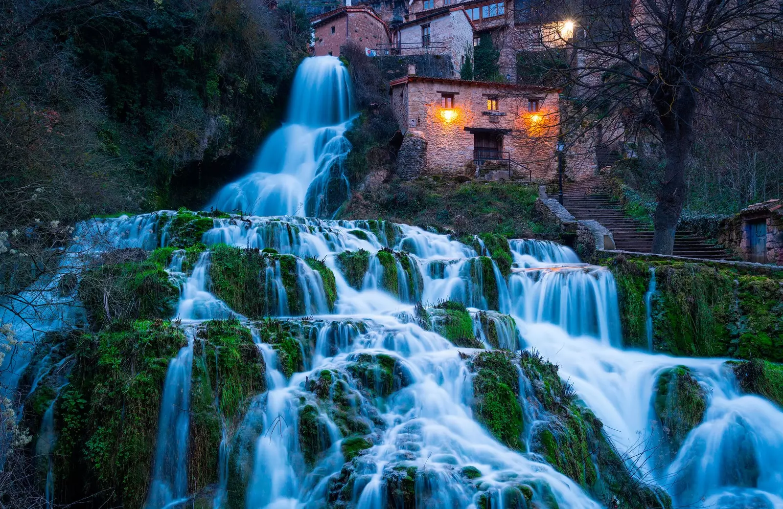
The most photographed picture of Orbaneja del Castillo
The spectacle of sunset and the full moon over Mount Bernorio, which is accessed via a livestock track, is unparalleled, and the peoples who inhabited it left on its summit burial mounds and menhirs to indicate his connection with the divinity. But not even the powerful mysticism of the place could prevent that it was taken by two Roman legions during the campaign of Emperor Augustus.
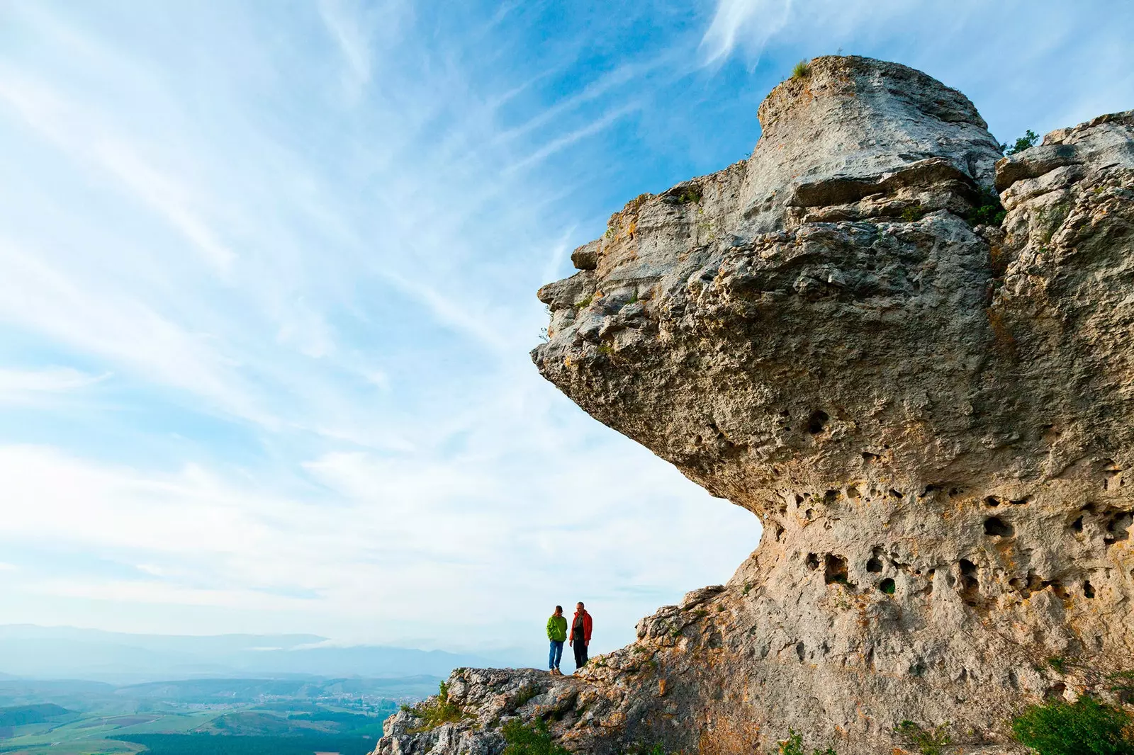
THE TWISTS (PALENCIA)
The Enchanted City of Cuenca has a first cousin on the heights of the Tuerces, a few kilometers from Monte Bernorio and Aguilar de Campoo. The call ladder of time Starts at Villaescusa of the Towers and, for two kilometers, crosses geological monuments consisting of corridors, alleys, cavities, mesas and large stone mushrooms which are the product of erosion caused by groundwater on carbonate rocks from the Santoniente period.
From the top of Las Tuerces, history is upon us as we contemplate the remains of the neighboring fort of Monte Cildá, another Cantabrian and later Roman citadel, as well as the railway line that runs along the bottom of the Horadada canyon, vital since the middle of the 19th century to communicate Santander with Palencia, Valladolid and Madrid.
Region once important as a communications hub, the towns that make up the Geopark are currently suffering from the endemic depopulation of rural areas, with the striking exception of the cookie core of Aguilar.
From the top of Las Tuerces, depending on how the wind blows, the sweet aroma of beet flour and sugar baked in the factories can reach us, but in most towns it is difficult to feel anything other than the weight of silence.
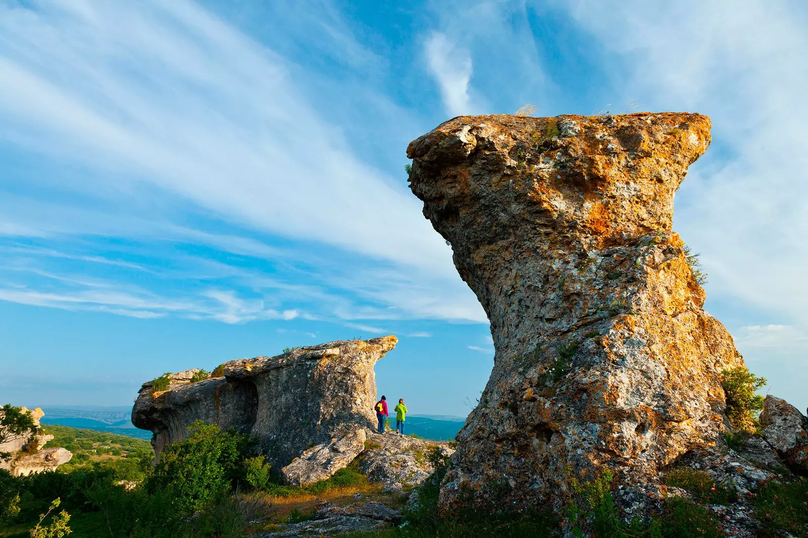
And feel small at the foot of these great stone mushrooms
WHERE TO EAT AND SLEEP
The villages of the Las Loras Geopark maintain in their kitchens traditional Castilian food, where you can not miss the products of the pig and the garden. Black pudding, torreznos, ear and nose in turn compete with the tasty Pisuerga trout and river crabs with which gigantic paellas like those of Pisuerga potters. This last town has, in front of the very interesting cave church of Saints Justo and Pastor (9th century), a picnic area by the river which is ideal for those who opt for a sandwich.
The most demanding palates should go to the restaurant of the hotel El Convento, in Santa María de Mave, where you can enjoy an idyllic setting that includes the outbuildings and gardens of a 12th-century Benedictine monastery.
The accommodations in the Geopark de las Loras are, for the most part, rural houses that have been able to rehabilitate or preserve the idiosyncrasy of the Campurrian dwelling. The stone dominates the constructions, although it is not uncommon to find adobe and wood houses like those that still rise in the neighborhoods of Calf of the Carpio.
It is precisely in the small closed valley where they rise the neighborhoods of San Pedro and Santa María, gathered in the embrace of imposing mountains and crossed by the Camino Real and the Camino Olvidado de Santiago, where one will be able to experience the sensation of living in the Middle Ages.

The most demanding palates should go to the El Convento hotel restaurant
The rural house El Fresno, in Barrio San Pedro, It is an old noble house with a familiar aroma, but if you want something more authentic, look under Mount Bernorio.
There, in Pomar de Valdivia, the rural house Puerta de Covalagua, run by a friendly local family, will show you what life was like in the towns of empty Spain and how it refuses to disappear thanks to the efforts of those who, like the ancient Cantabrians, refuse to abandon it.