
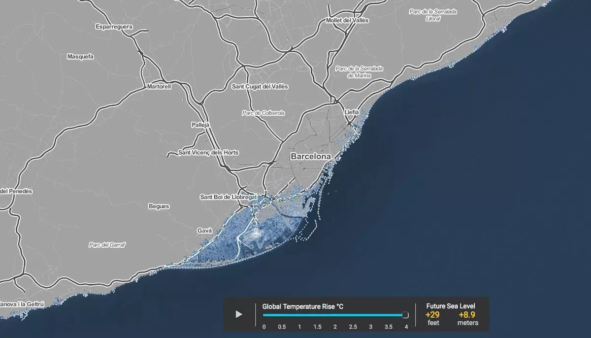
This is what Barcelona would look like if the temperature in the world increased by 4ºC
A 4ºC rise in global temperature would mean a rise of almost 9 meters in sea level in Barcelona, where the water would engulf, for example, Barceloneta or El Prat airport. Also forget about bathing in the incredible Malvarrosa of Valencia and enjoying the beauty of its Albufera. The Doñana National Park would be completely submerged by water and we hope you have enjoyed the landscapes of the northern coasts because they would not last long either. This is how it shows us Surging Seas .
"Every fraction of a degree of global warming sets in motion sea level rise that will end up massively threatening the world's coastal cities. . Each fraction of a degree avoided will save some of them," writes Benjamin Strauss, vice president of Sea Level and Climate Impacts at Climate Central, the nonprofit organization responsible for this map, on the Before the Flood documentary website.
His work focuses on research and outreach to provide authoritative, science-based information to help citizens and policymakers make sound decisions related to climate and energy.
Since a picture is worth a thousand words, ** ClimateCentral's Surging Seas ** is a necessary map with which to visualize the The consequences that the increase in the world's temperature and the rise in sea level that it entails would have on coastal cities.
The user can choose the area of the globe that he wants to visualize and, once on it, play god by deciding how much to increase the temperature (between 0.5ºC and 4ºC). With these parameters set, information about the meters that the water of our seas and oceans would rise and how these would engulf the coasts and their cities. You can see the map on this website.
The purpose of this tool, which displays data from research led by Benjamin Strauss and Scott Kulp of Climate Central together with Anders Levermann of the Potsdam Institute for Climate Impact Research, is show the threats that different sea level rises would pose depending on the pollution generated by carbon emissions.
According to data managed by Climate Central , between 470 and 760 million people currently live in the places that would disappear if the world's temperature increased by 4ºC . Most of the sea level rise shown on this map comes from the melting of Greenland and Antarctica due to global warming generated mainly by carbon emissions, they explain on the website of this map.
_* Images are the work of visual artist Nickolay Lamm _