
The road trips understand an innate romanticism : pack your bags, load the car, get behind the wheel and, never better said, hit the road and blanket. But they also carry a high level of danger . These types of trips require our full attention, but not all responsibility falls on the driver, but also on those roads that lack absolute safety.
Budget Direct , the car insurance brand, has joined the marketing agency NeoMam to create a detailed map indicating what they are the most dangerous roads in each country (or, at least, of those that have accident rates). A way to let us know the path and to warn us of those sections in which we will have to exercise extreme caution.
This is not about looking for blame, but about, even knowing that there are more and less responsible drivers, taking into account that there are also better and worse roads. This time, they get into the car to travel the world through its roads , but while emphasizing that, regardless of the reason, the horrible news is that each year 1.3 million people die in traffic accidents.
If we talk about Spain, the danger lies in a road in Barcelona.
ARE THE MOST BEAUTIFUL ROADS ALSO THE MOST DANGEROUS?
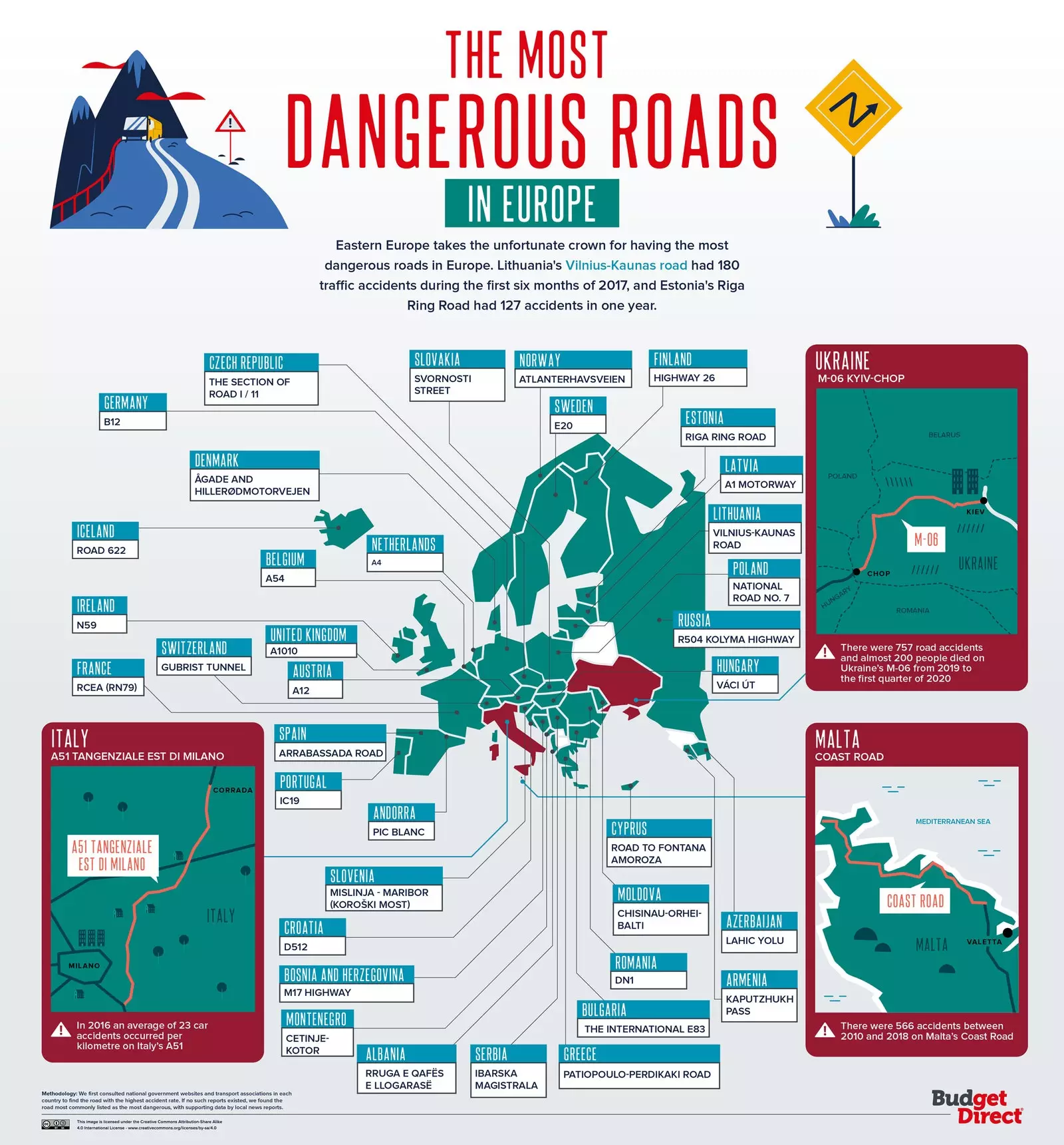
Not always, but yes on many occasions. If we focus on Europe , the clear example is iceland route 622 . We all know how nature spends it in this country, a waste of beauty that overflows its borders. Thus, it is logical that a road on which the scenery is made up of cliffs and fjords can be attractive. However, it is the most dangerous of the place.
In Spain, the Arrabassada road It is already sadly known in Catalonia for its high number of accidents, and it has also become the most dangerous in the country . It connects Barcelona and San Cugat del Vallés, but its traffic increases considerably because it is also used for get to the Tibidabo amusement park . One of its greatest risks is the constant curves it has, as a result of its location, in the Collserola mountain range.
The data is alarming to the point of reaching 566 accidents between 2010 and 2018 on Coast Road, in Malta , for instance. But we also see it in Italy, with 23 accidents per kilometer in 2016 throughout the A51, a motorway in Milan . London is the city that takes the cake in the United Kingdom: more than half of the most dangerous roads in the country pass through it.
Broadly speaking, Eastern Europe reveals the worst results. The Vilnius-Kaunas highway in Lithuania had 180 accidents in the first six months of 2017 alone, and Estonia's Riga Ring road , 127 in one year. The numbers get tricky the highway connecting Chop and kyiv in Ukraine (M-06), with 757 accidents from 2019 to the beginning of 2020.
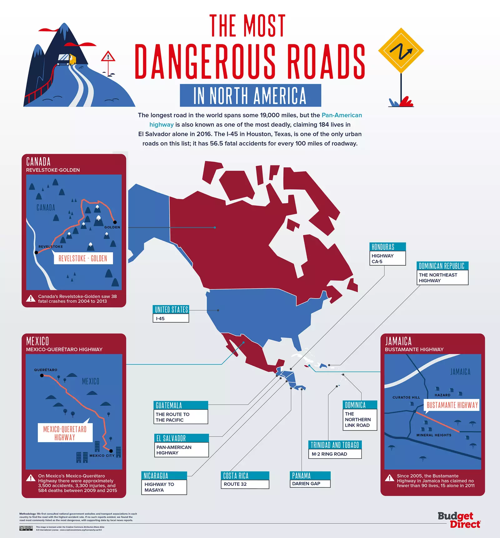
Mexico has seen 3,500 accidents between 2009 and 2015.
AMERICA
In United States , the greatest risk is in the Interstate 45 , which connects Galveston and Dallas through Houston, Texas. 56 fatal accidents It has been the number that this road has seen for every 160 kilometers approximately. In anticipation of an expansion of the road, Harris County has sued the Texas Department of Transportation to stop the project.
Canada reincarnates that lethal combination of beauty versus dangerousness, having the route connecting Revelstoke and Golden as the most unsafe road in the country, although with numbers vastly lower than in other cases: 38 accidents from 2004 to 2013. A totally opposite extreme to the numbers of Mexico , with 3,500 accidents (of which 584 were fatal) in the highway between Querétaro and Mexico City , between 2009 and 2015.
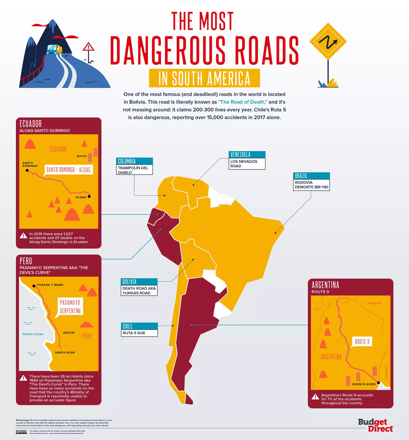
In South America, the names of the highways already approach the catastrophe.
If we go down to South America , what looked like a map begins to turn into a scary movie. Names resonate like Devil's Trampoline, The Devil's Curve or, directly without hesitation, The Highway of Death . You don't have to have a superior intelligence to know that these roads carry the written danger along their kilometers.
In Peru for example is found the Serpentine of Pasamayo , the famous Devil's Curve. With its 52 curves, its name is also given by the fog and humidity that occupy it throughout the year, a great fault of the accidents caused. However, the highest level of terror is produced by the Road to the Yungas, in Bolivia.
The latter, better known as The Highway of Death, has come to be considered as the most dangerous road in the world . Most of the route does not exceed three meters wide, with a drop of 600 meters. Given the loss of 200 or 300 lives a year , a safer alternative road was built, so it is now reserved for cycling and as a very popular tourist destination.
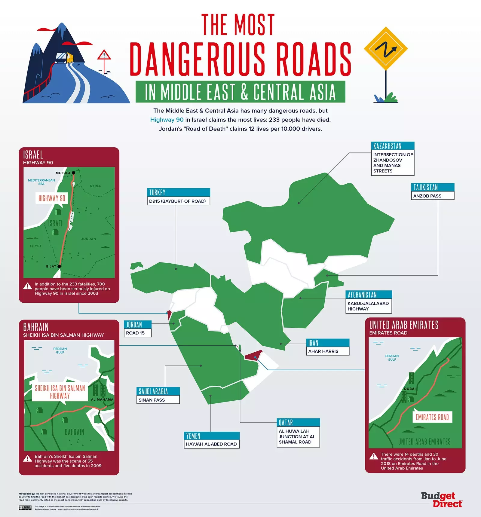
In just two weeks, in 2018, 17 people died on Israel's Highway 90.
MIDDLE EAST, ASIA AND OCEANIA
The next stop is the Middle East, Asia and Oceania. There, the names of the roads are still coincidences that seem to bring the terrible ins and outs closer. An example of this is the Dead Sea Highway, belonging to Israel's Highway 90 . In just two weeks, in 2018, 17 people died. Here, accidents begin to be more expected than normal, taking into account that the newer part was built in 1960.
As for Asia, specifically in China, the Gouliang tunnel It is among one of the most dangerous roads. It is located in the Taihang Mountains, crossing one of them. Since 1992, it has seen 400 traffic accidents . But the numbers go up when we move to Singapore: the Pan Island Expressway , the oldest and longest in the country, has had 441 accidents in a single quarter.
If we land in Australia , the number of people killed on its roads is one hundred a month, but it rises to 2,500 if we talk about injuries. The M4 motorway from Concord to the M7, in Sydney it sees 94,000 vehicles passing by every day, so it becomes a tricky stretch.
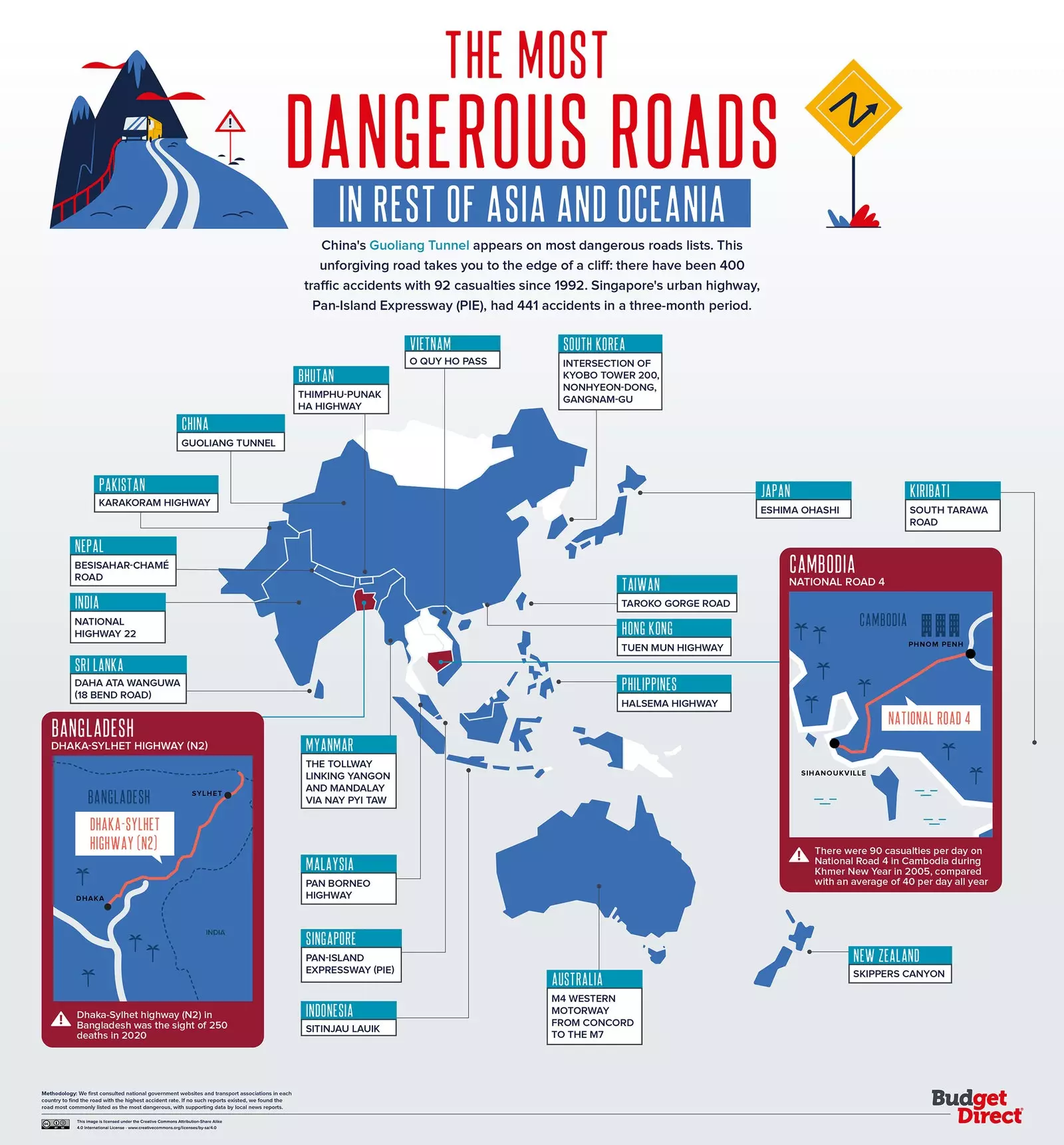
The Gouliang tunnel has 400 accidents behind it since 1992.
AFRICA
Africa is also not exempt from these fatal data. On the Douala-Yaoundé road in Cameroon (National 3) almost a third of the 3,000 annual accidents in the country occur. So much so, that the United Nations classified it as one of the most dangerous roads in the world in 2014.
Mombasa Road connects Mombasa with Nairobi, in Kenya . In just eight months in 2019, 27 people died. In Ghana, the road connecting Accra with Cape Coast hosts a total number of 6,104 accidents from 2004 to 2011. And on the Ugandan highway, which connects Kampala with Masaka More than 200 people have died since 2016.
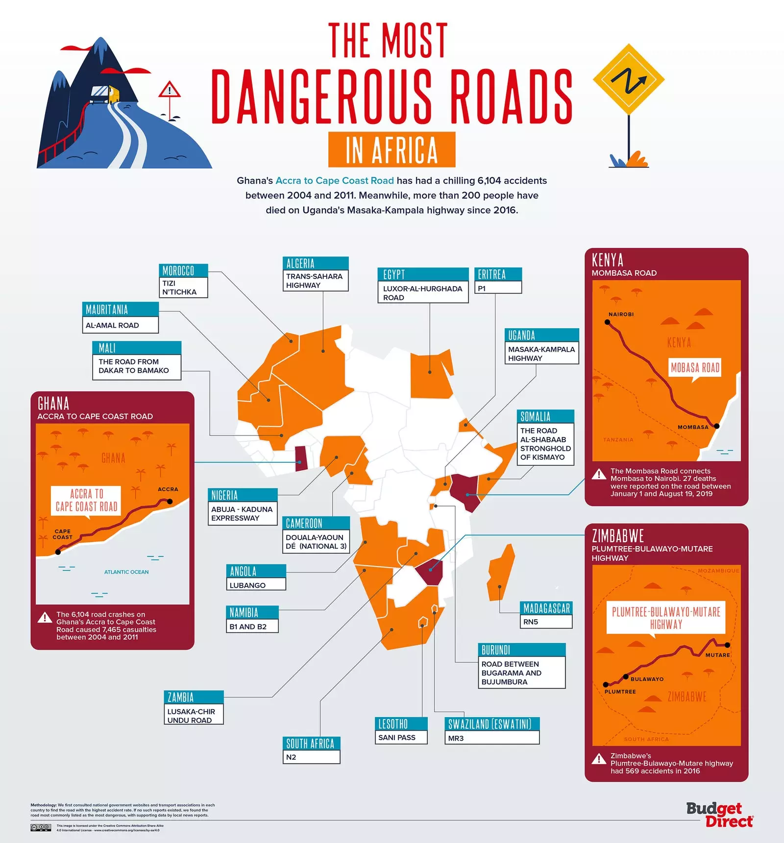
Cameroon's Douala-Yaoundé highway was listed as one of the most dangerous in the world in 2014.
We could continue looking at data, but the sad reality is that the numbers are updated every day because people keep dying on the roads. From Budget Direct they reflect on how the development of smart road networks and autonomous vehicles it could make them safer, but in the same way, their distribution would not occur in the same way in all countries, so some of them would continue to have a high volume of accidents.
For our part, we only have to do the only thing that is in our hands: drive with all the caution we can and be responsible behind the wheel. With this map, at least, we have knowledge about which roads should we avoid, although unfortunately, sometimes it is impossible for us.