
Barahona and Pedernales, sustainable hope
There are those who travel looking for pleasure and tranquility and there are also those who set out with the aim of living different and authentic experiences. For this second category of travelers who let themselves be surprised, the coastal route that starts from Santo Domingo, heading southwest, to flints , already on the border with Haiti , is essential for to understand both the diversity and the Dominican culture. Cliffs, virgin beaches, mountains, desert landscapes, lakes, simple people and that preserves the innocence of mass pre-tourism and the purity of the place make up the painting of an area with the greatest biodiversity on the island and that is destined to become the country's sustainable destination.
Unesco set its sights on it twelve years ago and declared the area of the Jaragua National Park , the mountain range Bahoruco and the lake Enriquillo What only Biosphere Reserve of the entire island: a protected area with a variety of microclimates whose landscapes range from the tropical coast to desert , going by mangroves, mountains, rivers ..., which allows a high level of endemism of the flora and fauna. For years, numerous bird watchers have come from all over the world, putting the Dominican southwest on the ecotourism map. This was the modest starting point for a model that is warming up today and is committed to a Green tourism and a recovery of the cultural manifestations that still survive from the Taino era.
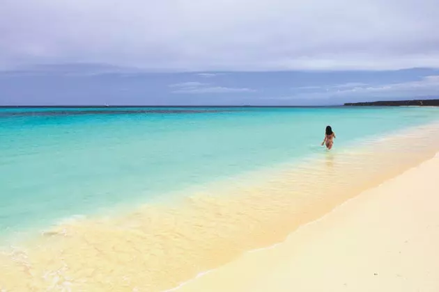
Warm and transparent waters of the Caribbean: the Bay of the Eagles
The best way to discover all its charms is to take it easy, enjoy leisurely . The area also offers accommodation proposals that are an experience in itself. One so gratifying that to enjoy it you have to dedicate several days to it.
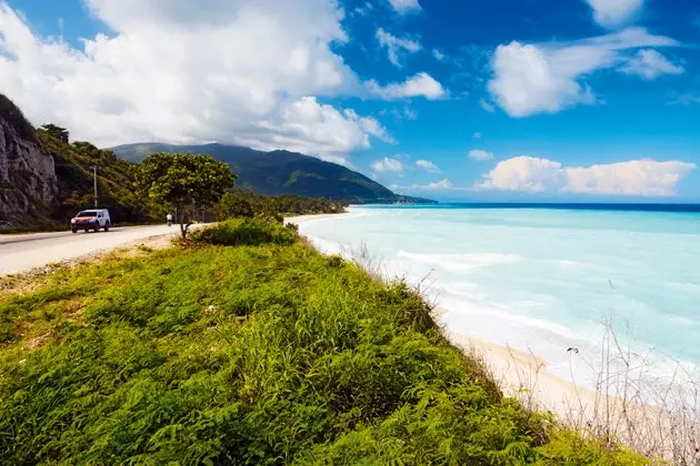
The most interesting journey from Santo Domingo to the bay of the Eagles runs on the road. The entire tour takes more than 4 hours. The ideal is is rent a 4x4 in the capital (Las Américas International Airport offers excellent options) and make a first journey of about 200 km to the city of Barahona . In this section, the road crosses the provinces of San Cristobal, Peravia (Bani, land of mangoes), Azua and Bahoruco ...and from this point on, you really start to appreciate the show of the sea to one side and the mountains to the other side of this winding road.
The city of Barahona does not have a great tourist development but can boast of being the cradle of the technicolor queen , the Hollywood actress in the 50s, María Montez. In addition, 10 km from the city are the Larimar mines in the town of Los Chupaderos , a semiprecious stone that only occurs in the Barahona region.
The road that goes from Pedernales to La Ciénaga
Also on the outskirts of the city Barahona , its beaches are perfect for taking a first dip, stretching your legs or eating something. And a good place for it (even to stay) is the Playa Azul Hotel, on a beautiful cliff with an intense blue as a backdrop. Its Franco-Dominican cuisine is the work of its owner, Sylvain, a Frenchman who has lived here for years and who shares the philosophy ' echo ’ of the destination: although the complex does not have access to the sea, they organize several excursions in collaboration with Ecotur (ecotourism agency).
But, if what you are looking for is a good bath in the warm and transparent waters of the Caribbean, following a few more minutes along the road, you will find Quemaito Beach practically empty, except for some fishermen who will invite you to cook a delicious fresh fish . Here there is no sand, only stones, but it is worth lying down under one of the almond trees on the beach, round-leaved trees that provide shade near the shore, and enjoy the lush vegetation that surrounds the area.
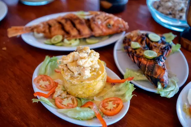
Fresh fish at Rancho Bahía
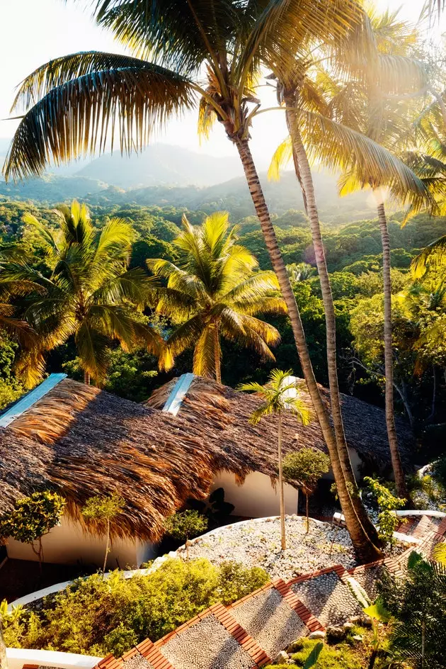
A few kilometers further on is the most chic lodging option in the area, Casa Bonita Tropical Lodge (see hospitality), a shelter in nature designed to relax, where one would want to stay and live. This former tropical manor house nestled in the mountain It does not have access to the sea but it does have one. infinity pool and a spa completely integrated into nature whose philosophy is to recover the ancient cultures of the area, using for their therapies natural products made there as coffee, chocolate, coconut, basil, bamboo, noni, mango or pineapple . One of the star rituals is the unlocking massage (A day in paradise), performed on a stretcher installed on the river current itself, whose waters, with mineral-medicinal properties, and relaxing sound envelop causing a state of semi-trance.
At night in the yoga pavilion, the magnificent scenery of the rain of fireflies and fireflies dancing in the middle of the forest among the trees, invites you to enjoy a romantic and unique show.
Sunset from Casa Bonita
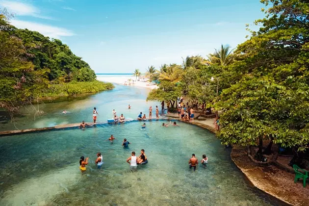
With a more popular atmosphere, the nearby beach of San Rafael combine the sea and a natural pool , created by the mouth of the San Rafael River, surrounded by green mountains . It is in the direction of flints , just before reaching the town of Paraíso. Through this area runs one of the most beautiful panoramic roads of the entire island, full of curves with a view of the Caribbean in the background.
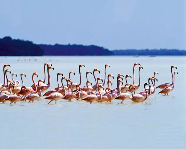
The lagoon of Oviedo It appears a few kilometers away. It is one of the best places in the Caribbean to bird watching , has 27 km2, 24 islands (keys) and water three times saltier than the sea. In its four species of mangroves inhabit the colonies of the endemic Ricord iguanas, the enigmatic Solenodont and the little hicotea turtle . Birdlife includes the Eurasian spoonbill, blue heron, seagulls, earwigs, pelicans, endemic parrots and flamingos. In addition, there are three trails: the walk of the flamingos , the Cayo de las Iguanas Y The Caritas of Guanal . For the first, although there is the possibility of accessing it by land through the community of El Cajuil, it is much more fun to do it by water, through the pier. Crossing of the Caños.
The natural spa and the beach of San Rafael
the path of The little faces offers, in addition to bird watching, the experience of walking a pre-Columbian path and visiting a cave whose walls show petroglyphs with human faces . Las Caritas was reached by a path of about 30 meters that ended in the cave and from where you had the best view of the lake. In addition, one of the pre-Hispanic national heroes lived in said grotto for more than 30 years, the brave Guarocuya , which the Spanish called Enriquillo . It was in this very place where 1533 signed peace.
Returning to the road, you will begin to lose sight of the sea to enter a new ecosystem: the desert. Cacti and more cacti populate the landscape that leads to Pedernales, on the border with Haiti. Dozens of stores sell gasoline packaged in beer bottles at the foot of the road and everything indicates that from now on there will be very few options to find gas stations and people. As kilometers are traveled, the path becomes more complicated, the land begins to dress in red and so do the cacti. This tonality, which suddenly floods everything, is due to the proximity of the bauxite mines . The road leaves Cabo Rojo and its beach on the right, just one kilometer from the protected Bahía de las Águilas, the culminating point of the route.
Guarocuya beach in the heart of Barahona
To access your seven kilometers of virgin beach , protected (since 1983) by the Jaragua National Park (1,374 km2), it is necessary to rent a boat. You can do it at the Rancho Bahía de las Águilas, committed to the conservation of the environment, and which has six boats to tour the bay and enter its cliffs and coves. The excursion includes a stay of a couple of hours on the beach or in one of its coves to enjoy its crystal clear waters. Corals, starfish, pseudoterogorgian gorgonians, which look like skeletal bushes but are invertebrates, and seagrass beds abound here.
at the crossroads of red cape We can also take another route, the one that leads through the interior towards the Pelempito hole, in the Sierra de Bahoruco . As its name suggests, it is an immense hollow in the heart of the mountain range, two kilometers wide and seven kilometers long, surrounded by mountainous elevations around 1,000 meters high. In the migration season, all the birds that make the round trip from South America to North America pass through here. Its 1,500 meters of depth can be appreciated from the viewpoint of its visitor center and it offers the visitor the possibility of making trails on foot.
*** You may also be interested in...**
- Haiti, paradise is reborn
- Dominican Republic, above all with flavor
- Dominican Republic: the Caribbean without instagram
- Samaná: the time has come to activate
- The perfect islands to forget about autumn
- The Caribbean in 50 islands
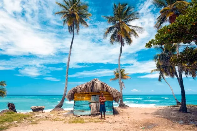
Fisherman next to a beach in Bahoruco