
What line passes through your city?
Rome , apart from being the cradle of art and an ode to beauty, was able to dominate a large number of European territories for years, expanding its power to the point of creating a network of roads that they shared the same origin: the capital of Italy . More of 400 tracks and close to 100,000 kilometers connected every corner of the Empire with the Eternal City.
Anyone who lives in a big city knows that distances are measured in subway stops , that borders are marked by transfers and that sharing the same underground route back home with someone is a success. Therefore, if there is a plane that for sure passes at least once a day through the hands of half the inhabitants of a metropolis , is the subway.
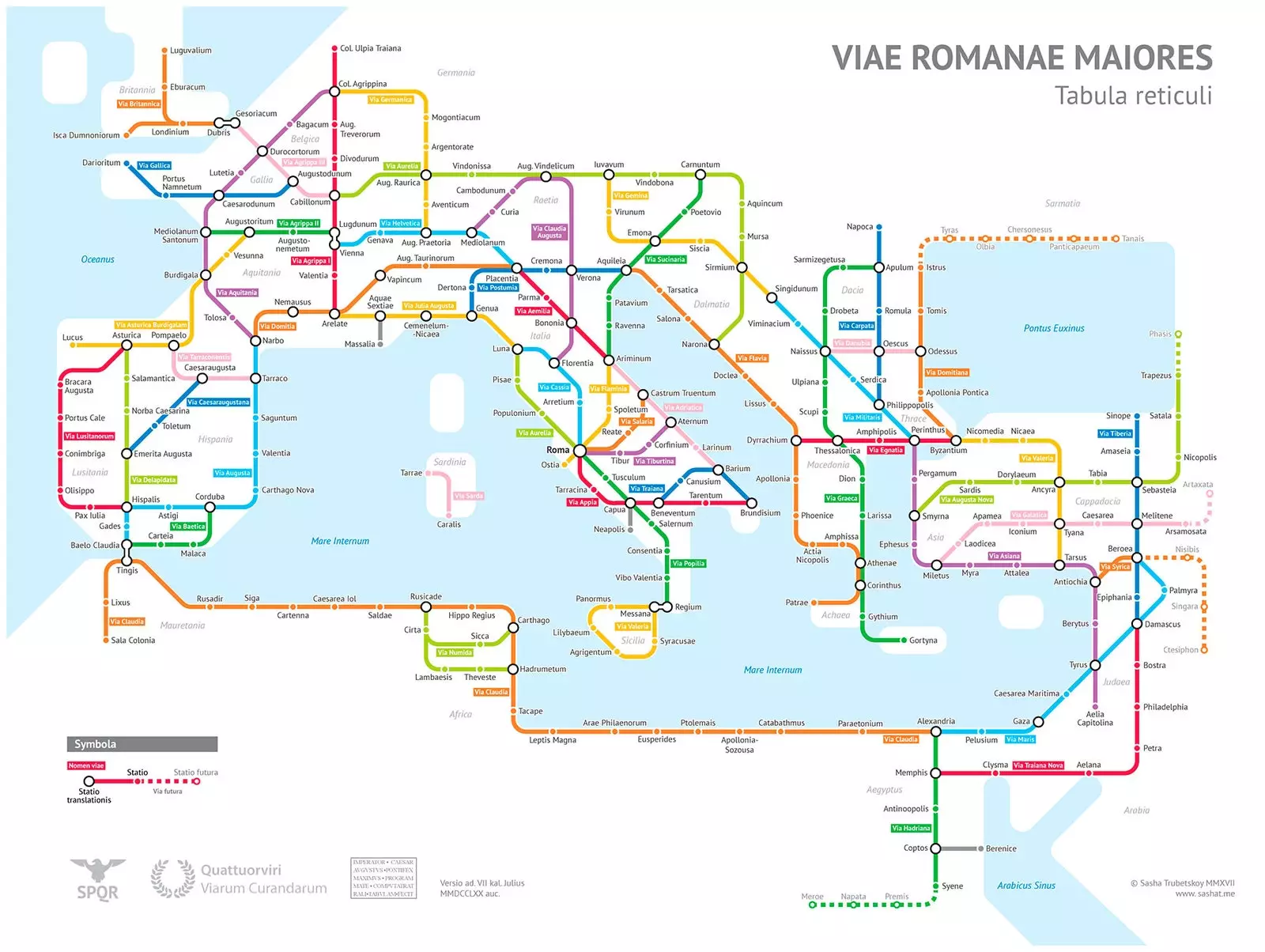
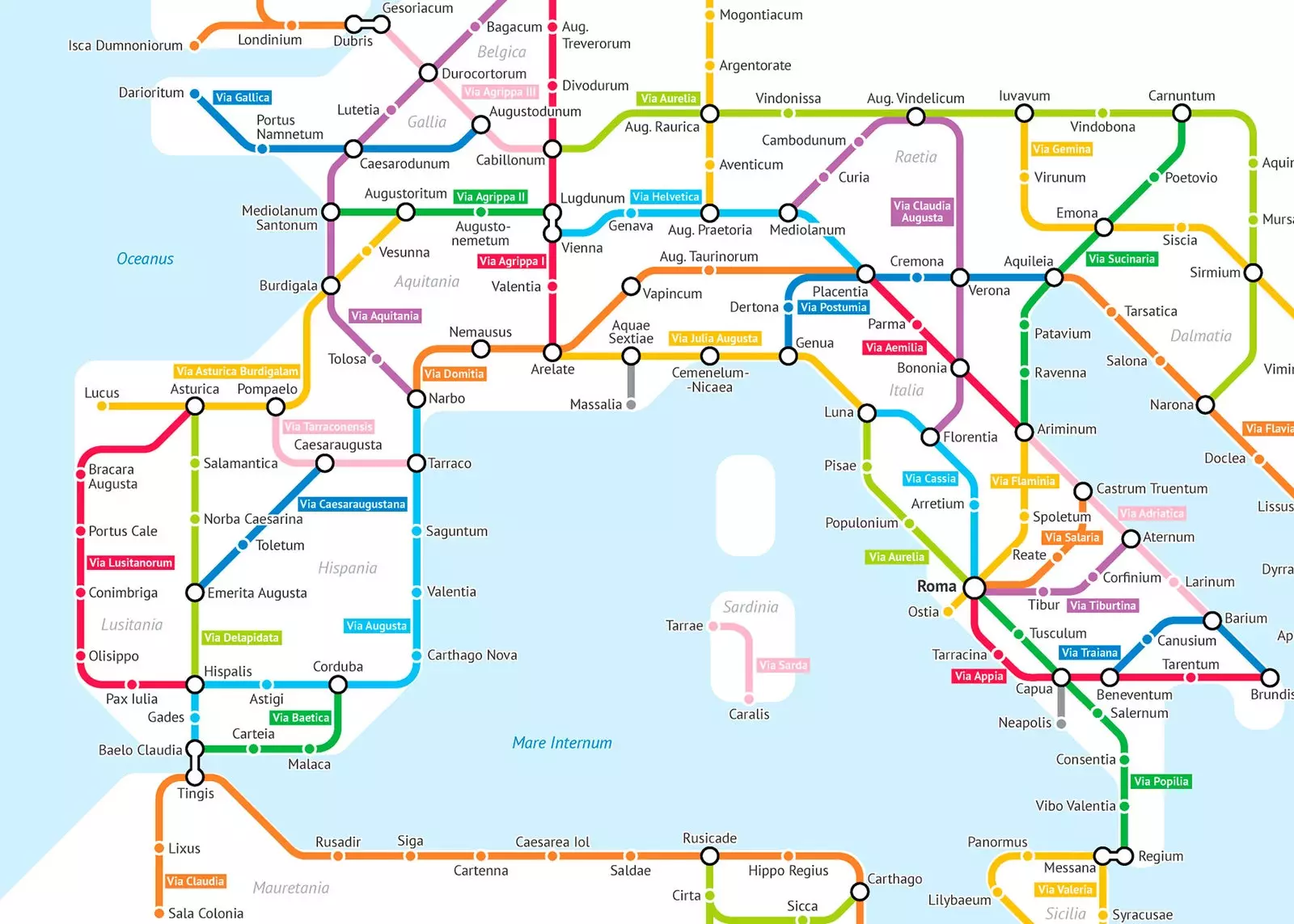
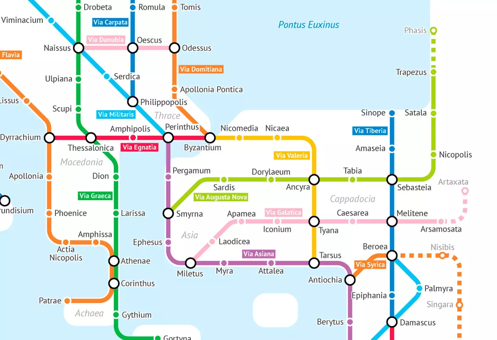
The map of the main Roman roads in Europe
This map, based on the Roman Empire of the year 125 AD. , represents the main roads of that time of splendor. As it was an arduous task to trace all the routes, it only includes the cities with the largest population and the provincial capitals of the 2nd century. The colored lines make the similarity to a subway map obvious, but here the minutes between station and station are converted into hours.
Its creator is Sasha Trubetsky , a american student who is in his fourth year of Statistics at the University of Chicago . In addition to being focused on his university studies, he works as a consultant for the World Bank in the area of urban development. In his free time he is dedicated to cartographic projects , like this wonderful map.
“My favorite thing about maps is how great they are at Turn raw information into something useful. as humans, our brains are wired to perceive things visually and spatially. By taking data points and representing them geographically, we use brain circuits that allow us to detect patterns and **explore the data as if we were traveling through the map**”, Sasha Trubetskoy tells Traveler.es.
How many stops have you already been to?
To create this original roadmap, Sasha Trubetsky used data from original sources such as the Tabula Peutingeriana or the Antonine Itinerary , as well as modern fonts such as Stanford Orbis and the digital map of Pelagios.
But why Rome? “I have always highly valued Ancient Rome and its advanced technology. He wanted to connect modern people to the ancient world in a way that was familiar to them. Everyone has seen a subway map, and if I translated the roads of Ancient Rome into this visual "language," it might make people stop and think about how similar we are through time. ”, explains Trubetskoy.
Apart from outlining the map of European Roman roads, the student also wanted to focus on designing a particular one of Britain and, of course, of Italy , which have been improved since its inception.
“ There were some minor changes between the British and Italian versions of the map. I decided to fill the sea completely, rather than the halo effect that **Great Britain** had, which I decided was a bit distracting. As for the context, i added the names of modern cities in small gray text , something that some people had suggested,” says Sasha Trubetskoy.
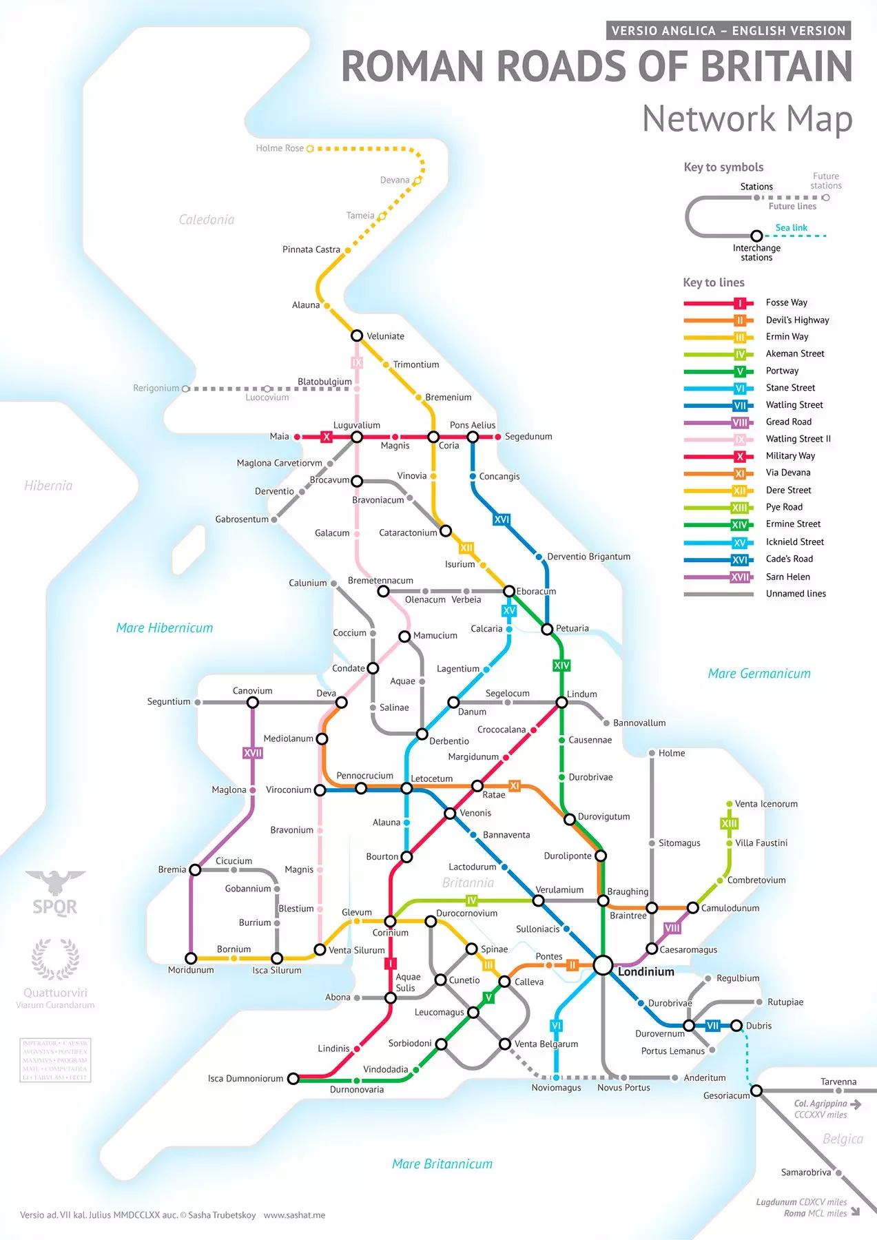
The main Roman roads in England
“I also included a small map of the city of Rome as it was very important. Little details like rivers, volcanoes and sea routes they helped add a bit more life to the map. **Roman Roads of Italy was my third metro map**, and with each map I think my style is maturing more and more,” Trubetskoy clarifies.
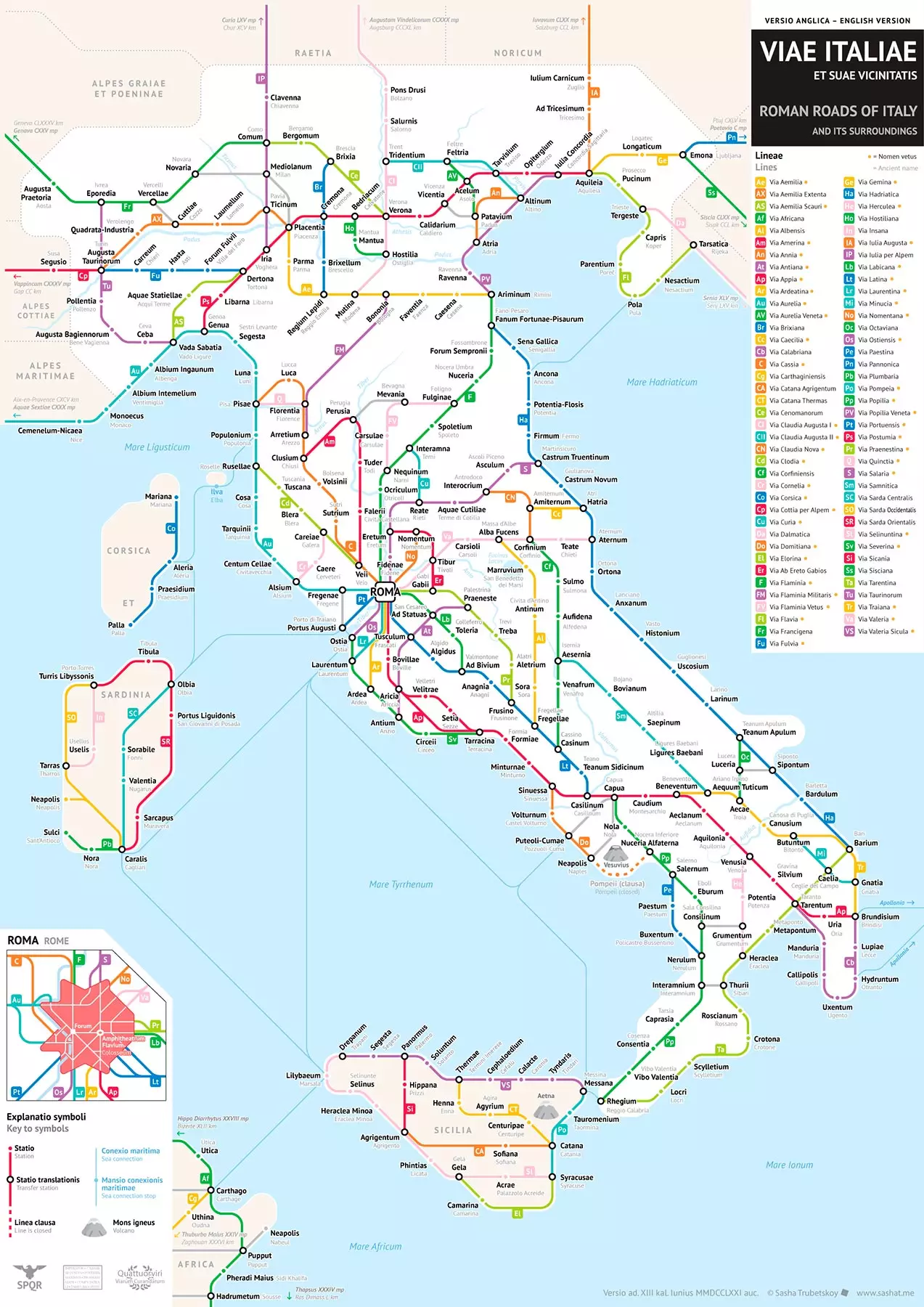
Map of the Roman roads of Italy
“ I knew I was going to be inspired by a subway map before deciding to focus on Ancient Rome. It is a form of map that is very open to design. I saw a lot of poorly designed maps like this on the internet and I wanted to make it better. So, I was partly motivated by the competition and, on the other hand, the curiosity about this format”, Sasha Trubetskoy confesses to Traveler.es.
“I am excited about my future maps. I plan to take a closer look at other regions, especially Spain. Much of the support for my maps has come from Spain and I want to thank my Spanish fans. I'm currently very busy, but this It's something I'll try to do in the next few months ”, reveals Sasha Trubetskoy to Traveler.es.